1.MAGLEMOSE AND KUNDA ORIGINS
The Post-Glacial Development and
Expansion of Boat-peoples
Synopsis:
At the end of the Ice Age, the world
climate was warming very rapidly -becoming as warm or warmer than today
by about 10,000 years ago, when the great glaciers were still very
large. This warming caused the northern lands to be flooded with
water, and turn former reindeer tundra into marshlands, lakes, rivers
and seas. Reindeer hunters had to give up their tradittional reindeer
hunting and adapt to the watery environment, including boats just to
get around. Although humans were smart enough to
devise rafts to cross bodies of water we are not by nature
water-creatures; thus the evolution of a part of humanity into a life
using boats and getting around on water could not have occurred
spontaneously just anywhere. It had to have occurred in a place where
there was no other alternative; where survival depended on it, and the
pressure lasted many generations. Through
natural selection those groups who devised the best ways of dealing
with the watery environment were the ones who produced the largest
populations and flourished. The following presents the basic
story - including some original discoveries - about the
appearance and expansions of a boat-oriented way
of life that marks an early stage in the evolution of Europe after the
Ice Age. This side of the European past has never before been told,
because traditionally scholars have focused on the land migrations and
the evolution of
farming and sedentary civilizations particularly in the Indo-European
tradition. Everyone imagines that European civilization owes its
existence to farming, but it owes as much to the development of
boat-oriented ways of life as it created the transportation and trade
that tied the civilization together.
Boat People Emerge from European
Reindeer People
FROM CLIMATIC,
GEOGRAPHIC AND ARCHEOLOGICAL
INFORMATION
The story begins at the
height of the Ice Age, when glaciers cover the entire north part of
Europe. In southern Europe there were people who lived in caves and
hunted bison, horses, reindeer and other large animals who lived in
plentiful grasslands or steppes, or towards the north permanently solid
tundra.
FIG 1
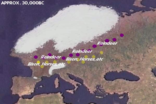 Map 1.
The Ice Sheet over the north of Europe.
Humans
who followed Reindeer, Bison,
Horses, Aurochs (wild cattle) and other migrating herds were
distributed according to the
migration patterns of these herds. Missing from the map is mammoths,
but mammoths became extinct in the course of the Ice Age retreat . As
the Ice Sheet withdrew and humans
began expanding northward, the first split was between the reindeer
hunters who occupied the tundra of the North European Plain, and the
descendants of the horse and bison hunters who were forced to adjust to
the
disappearance of grassy plains and plains herds.
Map 1.
The Ice Sheet over the north of Europe.
Humans
who followed Reindeer, Bison,
Horses, Aurochs (wild cattle) and other migrating herds were
distributed according to the
migration patterns of these herds. Missing from the map is mammoths,
but mammoths became extinct in the course of the Ice Age retreat . As
the Ice Sheet withdrew and humans
began expanding northward, the first split was between the reindeer
hunters who occupied the tundra of the North European Plain, and the
descendants of the horse and bison hunters who were forced to adjust to
the
disappearance of grassy plains and plains herds.
But when the Ice Age came to an end, the climate
warmed, and the southern parts of Europe became increasingly forested.
Grasslands and steppes vanished, and brought an end to herds of many of
the
steppes animals. Bison and horse herds migrated into Eastern Europe
where the
climate remained dry and there were still open country with grassy
steppes.. (Possibly
those hunters who followed them were the source of the '
Indo-Europeans' who adjusted to the decline in large animal herds by
starting to manage them - the first step towards domestication.). On
the other hand reindeer were animals who lived on
the tundra plain north
of the tree line. Forests could not swallow up tundra in the same way
they could swallow up steppe grassland, because trees could not grow in
arctic
conditions. Thus there was always a northern limit to trees, and beyond
that a tundra plain which could be inhabited by reindeer. Those humans
who sought to continue the way of life of the Ice Age, needed only to
shift north with the reindeer as they kept north of the tree
line.
REINDEER PEOPLE
The story of the boat people begins with the reindeer hunters.
Archeology reveals that the latest reindeer
hunters in continental Europe were in the region of Germany and Poland
around 13000
years ago. These were
about 90% dependent on reindeer, and therefore had needed to follow the
reindeer north as the climate
warmed. The northward shift would have been so gradual the reindeer
people would not have been aware of it; but over hundreds of
generations the northward shift added up to a great distance. By about
8000 years ago they would have been in the northermost reaches of
Greater Europe. As long
as their circumstances and way of life was unchanged they carried
forward the original language and culture of homo sapiens of the Ice
Age.
During the continuous northward shift of the
tundra, the reindeer hunters remained in arctic conditions. Staying in
arctic conditions the reindeer
followers continued to develop increasingly pronounced
mongoloid features, which are considered adaptations to the arctic.
(Eye squint against glare of snow, flat face to prevent wind flowing
over the face, squat body to reduce heat loss, etc. On the other
hand, those people of the Ice Age who abandoned the arctic conditions
early, did not have the natural selection forces on them and so, in
southern Europe, the arctic racial features are absent.
It follows that the modern peoples with highly
arctic
mongoloid features and traditions of reindeer hunting/herding - such as
the
Samoyeds of arctic Russia - are descended from the reindeer hunters. We
can also include the reindeer Saami in arctic Scandinavia today.. The
Samoyeds around the Tamir Peninsula are quite separated from the
Saami of arctic Scandinavia and one might wonder if it is valid to link
them together. In my view the Saami represent a mixing at a later stage
between reindeer and boat peoples in arctic Scandinavia. As
you will see later, when the glaciers shrunk over Scandinavia, the
northern part was free first and it would have been at that time
that the Reindeer-Saami ancestors entered the arctic regions.
The
boat peoples who went north to hunt the sea life of arctic waters in
skin boats would have encountered and mixed with the already
established reindeer hunters at that time. (See later)
ORIGINS OF THE BOAT PEOPLE
While the reindeer people were gradually
following their herds northward and the North European Plain turned
into bogs, lakes, and forests, the descendants of the people who
remained behind were adapting to new conditions.
How did some of the reindeer people get left behind? Whereas the
reindeer herds and their hunters could easily shift northeast and stay
above the tree
line from the
region now Poland (look up the archeological Swinderian Culture), towards the
west, in what is now Germany) the reindeer were unable to
continue north as the sea blocked the way, and these reindeer hunters
(look up Ahrensburg Culture) were
the first to have to adapt to the warm, waterlogged, landscape. The
last of the Western
European reindeer herds were hunted almost to extinction in the British
Isles.
As the originally
solid frozen land
turned to bogs and forest and the reindeer herds dwindled, the tribes
in these regions had to gradually turn to other animals to survive.
From
Poland
west to Britain, humans soon
found themselves in a marshy land where it was difficult to walk . That
began the environmental pressure that promoted a way of life moving
about in canoes made from logs. This original boat-people culture has
been called the Maglemose Culture.
Not all the reindeer hunters in the region of Poland
(Swinderian Culture) had been able to continue with the reindeer and,
borrowing from the dugout boat innovations of the expanding Maglemose
Culture, they made large dugouts capable of going out to sea and
hunting seals and whales. Perhaps colonies of seals or walruses
reminded them of herds of reindeer and they were able to transfer
skills in hunting reindeer to hunting sea animals like seals. It is
important to note that in reindeer hunting there may have been the
practice of ambushing reindeer from rafts as they were crossing rivers.
This would be a precedent that would be useful. Creating a boat for
hunting was not completely without precedent. These first seagoing boat
people are archeologically known as the Kunda Culture.
These descendants of both late Swinderian and early Maglemose Culture
were, like all boat people became, extremely mobile (since they could
travel much further and faster in boats than even reindeer hunters on
solid ground on foot). Like all hunter-gatherer people at any time in
history, they had a sense of ownership of the lands and waters in which
they hunted and it was their territory. They managed and defended their
territory - each family in a tribe their subterritory - from
rival tribes. But because of the mobility their range was very large.
Judging from similar situation in North America with canoe-using
Algonquian people a few centuries ago, the range of movement could be
3000 km wide, along the paths of water routes, of course. The Kunda
Culture was about 1000 km of coast, and extended up into what is now
Finland, and probably east as far as Lake Onega. But these were
seagoing people. They were more likely to expand, when their
populations grew, up to the arctic ocean. The dugouts intended for
rivers and lakes, had probably already been expanding since the
Maglemose Culture, because archeology has found evidence of that kind
of culture on banks of prehistoric rivers and lakes, as far east as the
Ural Mountains region.
Thus the Maglemose Culture was the beginning of the
boat peoples. During the several thousand years since it emerged around
Denmark, around 11,000 years ago, it expanded eastward through all the
marshy interior regions. The seagoing offshoot, the Kunda Culture,
began a second trend which saw boat people expanding north to the
arctic ocean, and inventing skin boats because the trees were too small
for making large seagoing dugouts.
In terms of the original dugout canoes, remnants of
ttheir dugout
canoes dating to as much as 10,000 years ago have been found preserved
in bogs from Britain to Finland. If actual remains of dugouts cannot be
found, the stone adze reveals the making of dugouts. The dugout was
made by burning the wood and using the adze to chop away the coals in
the direction you wanted the burning to go. Where coals were not
removed, the burning stopped since the coals created a barrier to
oxygen needed for burning. (The method is still found
among the Khanty/Ostyaks of the Ob River.)
Thus to summarize, the best theory to explain
archeological discoveries as well as the results in surviving
languages. is that the
boat people began as people who were unable to continue as reindeer
hunters in the central and western parts of the North European Plain
and gradually adapted to a watery and forested landscape which featured
dugout canoes to get around. Archeology sees the new way of life in the
Maglemose culture and Kunda Culture, then sees this culture spread
eastward via the
waterways changing slightly with new circumstances. Archeologists like
to give different "culture" names based on location,. or some special
material culture feature, but the original expansion was still
essentially the Maglermose Culture.
The expansion occurred during about 11,000 - 8,000
years ago. During that time all the waterways connected to the Baltic
and North Seas (the regions of the Maglemose and Kunda origins) would
have been explored and all the new tribes that arose from the
population explosion would have found their place within various water
systems (since they travelled by canoes). Because boat people travelled
so widely,.with range of seasonal migrations maybe 5 times larger than
what was covered earlier by the reindeer hunting people, they would
have had frequent contact with other tribes, and when there is contact
over such large distances, the language will tend to be quite uniform.
(A good example would be of course the wide distribution of the
Algonquian languages covering the northeast corner of North America.
The Cree language for example, covered 3000km around Hudson Bay, with
only three dialects. Just to their south were the Ojibwa (Anishnabe)
whose language was close enough to Cree to communicate. The evidence is
there that there was a common language similarly in boat oriented
hunter-gatherers in the region between Scandianvia and the Ural
Mountains, with only dialectic variation according to different water
systems.
What was the language of the original boat
people?
The
short answer is that it is most proper to speak of the "Finno-Ugric"
languages, since using "Uralic" will include the Samoyeds, which are
descended from Asian reindeer peoples, and have no connection to
water-based life. The "Uralic" family tree concept, which may still be
found in books, is to be abandoned. It originated in the 19th century
long before archeology had revealed the story of the Ice Age and
aftermath or N-haplogroup genetics. The Finno-Ugric languages are
best viewed as the result of boat people expansion from 10,000 years
ago to about 8,000 years ago, followed by the establishing of dialects
within the four major water systems. Since the Samoyeds do not
belong in this group. and there is no tight Ural Mountains origins, the
term "Uralic" is no longer appropriate. The best is to speak of
"Finno-Ugric" and "Samoyedic" separately and allow the "Finno-Ugric"
origins to be in the east with the "Finnic" ("Ur-Finnic")
The
Emergence and Expansion of Water
People
THE MELTING GLACIERS CREATE A WATERY LAND :
"UIRALA"
At the peak of the Ice Age, the glaciers
descended to the central part of continental Europe. Geologists tell us
that as the glaciers developed they drew water out of the oceans and
lowered the sea level. When the climate began to warm, when the Ice Age
receded, when the glaciers melted, the sea level did not rise
immediately because the glacial meltwater first spilled into the land
and inland seas and it would take some time for the water to flow to
the sea and raise its level back up. Thus there was a period of time
during
which the lands below the glaciers were inundated, and any hunters
found there would have no choice but to develop ways to travel on
water. Gradually they adapted and soon they had access to a rich bounty
of fish, sea-mammals, and waterfowl, not to mention animals that like
water like the "moose" (American English) or "elk" (British English).
Paleoclimatologists tell us additionally that the
Ice Age receded initially slowly, and then accelerated. For 10,000
years climatic change was barely perceptible, but then around
10,000-6000BC the warming was very fast. The reason for this is that
when most of Europe was covered with glaciers, its white color
reflected the sun's rays back into space. But as the melting progressed
and the dark colors of the earth were exposed, less sunlight was
reflected back into space, and the heat gain of the earth accelerated,
causing the glaciers to melt faster and faster until in the very last
stages everywhere the land was warming and the glaciers were depositing
their water. Water was being dumped far more quickly than it could
drain to the oceans. It was a very wet land, but the boat-using
hunter-fisher-gatherers flourished, probably more than any other
people. It an be argued that the boat-people became the dominant group
in Europe. I call their watery world UI-RA-LA. It's peak of expansion
was at about 8000 years ago. Then climatic warming slowed down
again, the glaciers disappeared, water flowed into the sea,
and things stabilized in subequent millenia.
From the Preface, I show the following map of the
region around the rise of boat peoples at the time of maximum warmth.
FIG 2.
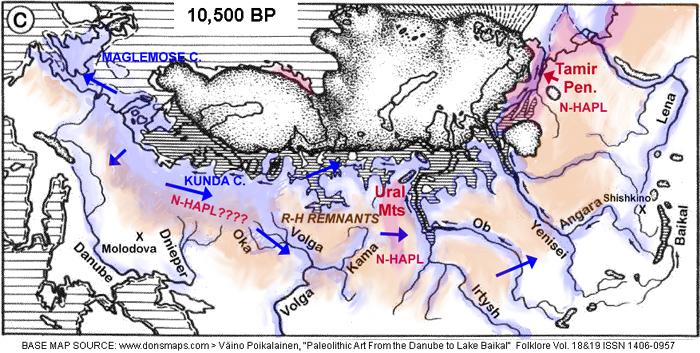
The
blue tone and blue arrows represent the initial expansion of the boat
peoples. The pink tone represents actual surviving reindeer hunters and
herds. The orange tone represents former reindeer hunters left in an
open subarctic landscape who had to hunt other animals like moose and
move around on foot as before. The boat peoples was one of the
adaptations that was very successful. Less successful solutions to the
loss of reindeer herds and the warm climate would have borrowed boat
use, just as later in history, people borrowed farming practices. Once
invented and mastered, anyone could copy.
A WAY
OF LIFE INVOLVING BOATS
Today we take the use of boats for granted.
Because today anyone can purchase a boat and go fishing,
there is a
common belief that boats and boat use is something that could easily
arise from simply concieving of it and trying it. For example,
some scholars have said the idea for a skin boat could come from
watching a wicker basket float on water. But such experiments and ideas
are what humans do all the time - they are just amusements or toys. Or
they could be ad hoc contrivances to solve a one-time problem. The idea
is never adopted into common practical uses because there is no real
long term necessity.or usefulness for it.
Indeed, humans have always been
able to
put baskets in water and watch them float. Children can even climb in
them and play games. Another good example would be to
ride
on the back of a large animal. There is not doubt that early horse
hunters may have developed a sport of jumping on the back of the wild
horses and trying to see who could remain on the longest. But games,
amusements.or sport
would not become
established in that society until this practice of riding on a horse's
back became useful in the
way of life in general.
Another example would be the discovery of
electricity. Apparently a battery had been invented in ancient times,
but it was used probably as a novelty of some kind. It was a toy. Who
back then
could have imagined that one day there would be a world society that
actually ran on electricity?
The reality is that an idea does not become
established in a society unless
it is truly necessary and economically viable. The invention of
boats
had to represent improvements for a society that offset the natural
reluctance of the human being to take to water. The use of boats or
water craft like rafts were probably used by humans maybe back to ape
ancestors, since today we can see apes devising ways of crossing a
river on something serving as a raft. But these are one-time
solutions to challenges, and not something of continual necessity.
Indeed, the reindeer hunters from which the Maglemose and Kunda
cultures emerged had probably created ad hoc watercraft to ambush
reindeer crossing a river, the river slowing them down. The story of
the boat people is not the invention of the boat, just as horseback
riding is not the invention of it for a particular purpose, nor how
weeding around wild berry plants is farming. What we must see is
the practice becoming a central necessity in the way of life. Unless
you find yourself living in swamps, a boat is just a novelty or an
occasional practical device. Unless you live in open steppes, horseback
riding is an occasional practice. Unless you live in a location where
wild food cannot grow, farming is an occasional practice too.
At the origin of boats
you really needed a situation in which
humans needed to deal with flooded lands all the time, generation after
generation. Beginning with the need to cross waters to get from one
island region to
another, soon they found they could just as well hunt and gather water
animals and plants as well. This then promoted improvements to the
dugouts and the invention of new hunting practices that employed boats.
Once the
art and technology of using dugout canoes had developed not
only did it open up opportunities to hunt and gather in watery
environments, but the boat actually allowed them to travel some five
times faster than even walking on clear solid ground. The degree to
which the boat people recieved benefits can be the equivalent of the
later advantages of farming. Today's culture of automobiles on
highways, is based on an older one of horsedrawn carriages on roads,
but both are ultimately based on the oldest tradition in transportation
- boats on rivers. Without the boat-oriented way of life, and the
results in shipping and transportation, Europe today would not be much
more advanced as as large scale civilization than North America in the
17th century before European colonization.
ONCE
ESTABLISHED, AND PERFECTED, NO STOPPING IT.
Starting new inventions and new ways of life
using them, is very
difficult - there have to be sustained environmental pressures, and
there has to
be a long evolution from crude actions to a refined way of life.
That could take many generations.
But once the way of life has matured
and proves to be successful then other peoples can quickly copy it. Not
only does the establishing of it validate it for others to copy, but
new users do not need to progress through a long evolution anymore. By
simply copying, they derive the benefits immediately.
The development of horseback riding too, may
have taken a hundred generations to develop into a central role in a
society, but once it was established all other peoples could adopt
it. But it had to begin in a slow way accompanied by sustained
pressure.
With the
success in hunting and gathering, and travelling between bountiful
sites, it is no wonder that the populations of boat peoples blossomed
and caused tribes to divide and divide producing new tribes who
travelled further and further away to occupy the still-vacant coasts of
lakes, rivers, marshes and bogs from Britain to the Urals. It all makes
sense. The growth of populations of boat peoples probably
exceeded the
growth of any other post-glacial hunting people, and such growth
probably did not occur again until civilizations developed in southeast
Europe. In other words, a great portion of humanity today has the boat
people
at their roots. It would explain our love for recreational boating,
canoing, and fishing. Recreational activity tends to be connected to
ancient experiences that have found themselves into our human nature.
A Finnish linguist, Kalevi Wiik, a couple
decades ago, proposed that northern Europe originally spoke "Uralic"
(of which Finno-Ugric is the largest division). If the original boat
peoples arose from European reindeer peoples, and if after the
development of the use of boats, they expanded in every direction from
their north European origins, then indeed, before the development of
farming-based Europe, before the arrival of Indo-Europeans, northern
Europe could very well have spoken Finno-Ugric as Wiik suggested,
including all regions later recieving the Indo-Europeans that gave rise
to Celts, Germanics, Slavs and Balts. Wiik tried, in his papers in the
2000's to imagine how the Finno-Ugric boat-using hunter-gatherers
responded to the immigrant peoples, from the farmers to the cattle
herders in those millenia between 10,000 years ago and about 5,000 or
4,000 years ago. That is about 5,000 years of the original hunter
gatherer peoples with boats, north of the Alps, interracting with and
adapting to the presence of newcomers.
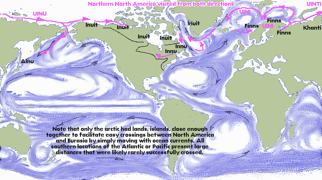
NORTH
AMERICA
Could there have been an independent
development of boat people in North America? Unusual developments need
special circumstances and sustained pressures. Consider that North
America had some large animals that could
have been
domesticated. An elk or moose could have been developed for uses
similar to horses - but it didn't happen. And yet when the Plains
Natives saw Spaniards riding horses they were quick to copy them
and the North American Plains Natives were riding
on the backs of horses within a couple generations after seeing
Spaniards use them.
When we consider boats, archeology fails to find
evidence of boats in North America predating about 5000 years ago. It
seems that boats did not develop independently in North America -
the same environmental pressures never materialized - but were copied
when the first skin boats crossed the north Atlantic from the coasts of
Norway. Consider that the Atlantic coast of North America never saw the
development of boats made of planks. All North American boats
were either dugouts, or skin boats on frames, which includes using
birch bark for skins. While northern Europe has rock carvings
dated to as much as 8000 years ago, showing both dugouts and skin
boats, all images in North America that show boats are relatively
recent.
Finland has red ochre images on rock walls that were
originally beside water, and made from boats, but all the images are so
degenerated it is difficult to make them out. On the other hand similar
red ochre paintings on cliffs beside water in the Great Lakes of Canada
are fresh enough that you can tell what the images represent. They
suggest visits from the arctic coast of Norway by aboriginal people of
Finnic origins (since they carried out exactly the same practice as
found in Finland)
relatively recently. See another Uirala article for more on North
American mirroring of red ochre cliff art beside canoe routes.
Crossings of sea-hunting peoples took place as well,
as will be discussed in a later article. The Inuit of arctic North
America is an example. We will look at such aboriginal sea-hunting
peoples in Northern North America for evidence of a connection to the
boat peoples of northern Europe who became seagoing.
The Structure of
Hunter-gatherer Boat Peoples Way of Life
THE EXPANSIONS OF THE BOAT PEOPLES
Originally, boat use may
have developed simply to deal with the fact that land suitable for
walking had disappeared in the North European Plain between 13.000-
10,000 years ago; but once the boat had begun to develop, unexpectedly
it offered great additional benefits - access to water plants and
animals, and ease of travel.
At the same time, the warming climate was causing
the populations of wildlife to increase as well - the marshes came
alive with waterfowl, fish, and even large animals like the
moose. This new way of life using
boats was successful, and the boat-people populations began to increase
in
parallel to the wildlife. Bands and tribes grew large, and daughter
tribes split off from mother tribes, and migrated far enough away to
establish a new hunting-fishing-gathering territory.
It is necessary to understand a little about the
social organization of nomadic hunting peoples - how they expanded, how
they interracted. We can learn a great deal about it by what is known
about the Algonquian canoe-using hunter-fishers of the northeast
quadrant of North America. The most important truth for scholars
to understand is that humans are territorial. You simply cannot say
that a particular people migrated into another area, without
considering whether there were already people there. If there were,
intruders were resisted, told to move on. If they did not, there was a
battle for supremacy. Scholars cannot treat the environment
as if it were vacant - except in the beginning. The boat people
originally expanded into virgin lands, but once the expansion had been
completed and tribes were claiming ownership over wildlife in different
regions, newer immigrants had to deal with those who were already
there. The newcomers could move on, or agree to take marginal lands.
Thus while the original expansion could cover the entire region from
Britain to the Urals in 1000 years, further waves of migration had to
deal with the established peoples - taking marginal lands, fighting
battles over ownership, and trying to find peaceful ways of sharing
increasingly limited resources. Note that in civilization we think of
lands in terms of acreage for farming. Hunting peoples did not have a
sense of owning nature, but owning rights to hunt particular
animals. A farming people could move into the territories of a
hunting people as long as they did not hunt. This is something scholars
do not understand. I recently read of how scholars studying the early
peoples of central Europe were puzzled that the hunting peoples did not
adopt anything from the farming people in spire of contact. Partly this
indicates a continued racism, where it is expected that aboriginal
people ought to want to become farmers. But mostly it is because
scholars do not understand that peaceful co-existence of two different
peoples requires that each side remains within their own economic
territory. It is interesting to note too that in Canada, the farming
natives known as "Hurons" were 90% dependent on what they farmed -
maize, squash, etc. They could have hunted and fished but they
were closely involved with the Algonquians - the seasonally nomadic
hunters-fishers. If they wanted meat, it would be more likely from
trade - meat for maize. If the Algonquians did not live in the same
environment, the Hurons would have been more involved with
hunting and fishing. Different peoples could occupy the same landscape,
as long as they exploited different resources. In other words concepts
of territory could overlap in the same landscape. Farmers,
traders, fishermen, crafters could - and later did - occupy the same
environment as long as they were clear as to staying within their
territories and respecting those of the others. It is the origins of
professions. Specialization plus trade also made for a better economy
for everyone involved.
The nature of hunting-gathering societies is clear
from what was observed of the North American Algonquins before the
arrival of Europeans disrupted them The organization of
hunting-gathering society is not designed by anyone, but the
consequence of human nature and necessity within a particular way of
life. In the basic aboriginal society humans
form bands, extended families of brothers and sisters, children and
elders, who then move together through a territory. But bands can meet
up with
bands, to form tribes. Evidence suggests that an average natural tribe
had about 5-7 bands.Anything larger was difficult to maintain, without
some organization. The pattern of life of nomadic
hunter-fisher-gatherers is that every band moved around in their band
territory throughout the year, but annually 5-7 bands would meet at a
central location to socialize, trade, mate, and generally reaffirm a
larger tribal social order. Thus the region of linguistic and cultural
uniformity extended over the total area of the movements of all the
clans of the tribe. Sometimes two or three neighbouring
tribes would congregate in larger festivals, and that would counteract
the development of dialects between one tribe and the next. If the
territory covered by a band of boat-using hunter-fisher-gatherers was
large, then areas of linguistic and cultural uniformity could be very
large, much larger than is commonly assumed.
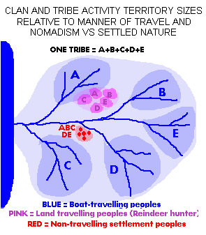
THE LARGE SIZE OF BOAT-PEOPLE TERRITORIES
An important and also unrecognized
aspect of the boat-peoples is that with boats, boat-using
hunter-fisher-gatherers could travel over five times faster and farther
than the earlier hunters that moved on foot over clear open land. That
means boat-using hunting-fishing-gathering territories could be over
five times larger than that of the earlier big animal hunters, like the
reindeer hunters. For example, if a reindeer hunter band covered a
territory 100km in diameter, the boat-users could cover a territory of
500km in diameter with the same effort. Furthermore, since boat-use was
determined by the
nature of the waterways, their territories would be stretched in
various ways. A linear territory could assume the form of travelling
1500km up and down a river, or along a coast. (For example, evidence of
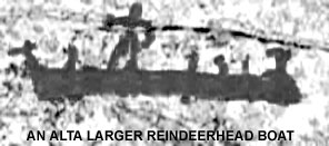
rock carvings with moosehead skin boats suggests that there may have
been a tribe that migrated annually between wintering at Lake Onega and
summering in the islands off the coast of arctic Norway. Lake Onega
images of moose do not show antlers - proof that these people were not
there in summer and never experienced antlered moose (antlers are lost
in the fall and regrown in spring).
TerrItory is very important in the human
psyche, and it follows that if the range of tribes with boats was this
large, then in the early period of expansion of the boat peoples, it is
clear that breakaway bands and then tribes would have to travel a great
distance
to remove themselves from the territories claimed by the parent band.
If families were having three children, then a breakway tribe would
form every 50 years or less, and move about 500km away. They could
expand 1000km in every century (The destination lands have to be
unoccupied, as mentioned above for that speed) The most recent example
of rapid
expansion of a boat-people is that of the Canadian arctic "Thule"
culture from Alaska to Greenland in only about 500 years.
As I mentioned above, the original
expansion (10,000 to 6000 BP) the expansion was unopposed. Before
the boat peoples there were
no previous peoples across the subarctic forest zone of Europe. Before
the evolution of boat-peoples the
water-filled forests south of the tundra were unoccupied. The only
people they might have encountered were the reindeer-hunters. But the
reindeer hunters were above the tree
line and moved around on foot, therefore they were rarely found in the
niche into which the boat-people expanded. In a sentence--the
boat-peoples were unopposed and for that reason the expansion was fast!
They did not have to displace any earlier
peoples. They did not have to battle with people already there.
This is something that we cannot understand
today. For several millenia now, any immigrant had to deal with
the people already established in a location. The days of simply moving
into virgin lands, and occupying them, has long
disappeared. Either the immigrants have to negotiate with
those already there, or come with an army and conquer them.
THE
PATTERNS OF EXPANSION
As already noted, because the
territories of boat people were large, when populations grew and tribes
formed out of parent tribes, the new tribes needed to travel far enough
away so as not to overlap the parental territory. That meant moving out
of the parental water basin into a new one. The entire region between
Britain and the Urals could have been filled in less than 1000 years.
Thereafter there would have been internal dynamics until territorial
stability was achieved -- everyone knew what regions belonged to what
clans and tribes.
A natural human tribe consists of 5-7 bands
(extended families of brothers and sisters, their children and elders).
(Larger tribes require political organization, government, to remain as
one.) From the Canadian evidence, the most common pattern among
boat-peoples is that the 5-7 bands each owned one of the water basins
of the tributaries of a large river so that the tribe as a whole owned
the entire river water basin. The bands travelled through their large
territories on their own for most of the year, and then they all came
together once a year to socialize, find mates, trade, exchange news.
The tribal meeting place was usually near the mouth of a river.
In the case of peoples who fished and
hunted sea coasts, perhaps a tribe was distributed along the coast,
each band claiming a part of the coast. Archeology shows that there was
a cultural unity along the south Baltic which they have named
"Maglemose". If the bands of this tribe travelled the coast, the
central location where the bands got together would have been at the
mouth of the Oder as it would be a central location. And on the east
Baltic the bands of the tribe archeologists have called "Kunda" would
probably have met at the Dvina (Daugava, Väina) at the Gulf of Riga.
The mouth of the Vistula would have been the gathering place of bands
who travelled the Vistula. If the three tribes wanted to meet in a
large gathering, the mouth of the Vistula was a good place. Archeology
has found overlapping of archeological cultures there. Another location
where it appears two or three tribes came together is Lake Onega.
These patterns are illustrated in the information
box below:
CANADIAN MODELS OF BOAT-PEOPLE BEHAVIOUR
There is no need to guess at the behaviour of
canoe-using aboriginal hunters in Greater Europe because proof
can be found in the traditions of
boat-using hunter-fisher-gatherers of Canada.
The further north the
people live, the lower the food density in the land, and the further
they had to travel to secure their food. Thus for example the Cree
around forested part of the the lower Hudson Bay, covered a territory
as much as 3000km wide, their far-ranging movements keeping the
language from breaking into many separate languages over that entire
area. (Europeans did however note three dialects). North of them, the
arctic ocean boat-oriented Inuit had established a single language,
with about three dialects from Alaska all the way to Greenland.
Towards the south, where food density
was greater, people did not have to travel as far. Shorter-range
interaction between peoples caused dialects over smaller regions and
for there to be suffiencient separation between the larger groups as to
develop distinct
languages (=dialects that are too far apart to be easily understood by
each other). For example in Canada, the Ojibwa boat-people lived
throughout the Great Lakes water basin, the Algonquins in the Ottawa
River water basin, the Montagnais Innu in the Saguenay River water
basin, the Labrador Innu in the Churchill River water basin. Note how
water basins defined the regions, since boat-use was generally confined
to the water basin. Within these divisions there were dialects too,
especially among the Ojibwa. To be accurate, the language varied in
relation to distance, and while adjacent tribes could understand each
other's dialect more distant ones had difficulty. Linguists
unfortunately do not think in terms of continua of language where
distinct languages only occurred where there was some kind of barrier
to communication. For example in the east Baltic coast, there would
have been a continuum of dialects up the east Baltic coast, but then
because of the obstacle of the Gulf of Finland, a dramatic difference
between the north and south side - the reason Estonian and Finnish are
considered distinct languages, while southern Estonian dialects would
have transitioned into the northern Livonian dialects, Livonian into
Curonian, and so on. In North America, it would have been
similar - the strong differentiation being caused by geographic
barriers or some other basis for separation. For example the Montagnais
Innu lived on the Saguenay River, so they would have to be different
from the Algonqjuins on the Ottawa River.
Once we understand the way the North American
Algonquian boat peoples divided up their activities in the Canadian
landscape we get to understand the early situation in ancient Greater
Europe very well. Notably we can predict that the Ob, Kama, Volga
Rivers (for example) would produce separations that would promote all
their languages drifting apart from a common parent. Thus once we
identify the early Finno-Ugric cultures as aboriginal boat peoples like
the recent Algonquians we can predict that linguists will find
linguistic differences according to the major water systems. Indeed,
that is what they found - the Ob-Ugrian languages on the Ob River, the
Permian in the Kama River water system, the Volgic in the Volga, and
the Finnic in the waters draining into the upper Baltic. It follows
obviously that if the expansion from the "Maglemose" culture of the
Jutland Peninsula (Denmark) is correct, then not very long ago there
must have been more Finno-Ugric families - perhaps a family on the
Vistula, perhaps descendants of "Maglemose" on the Oder, perhaps a
family in southern Sweden, perhaps even a Finno-Ugric family in
Britain. Such notions are controversial to everyone who has
fallen victim to the erroneous theory of migrations described
above.
The most primitive way of life among surviving
Finno-Ugric cultures are also the most remote - the Ob-Ugrians on the
Ob River which drains into the arctic ocean east of the Ural
Mountains. Even recently clans went up the river to spend part of
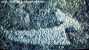
the year in their traditional campsites. They have been documented by
the films of Lennart Meri shot in the 1980's. The films include so many
primitive aspects that when I showed it to an Ojibwa friend in Canada,
he initially thought it was all staged and everyone was acting.
The film included icons familiar in Algonquian culture such as
the drum made by stretching skin on a frame, and the teepee
construction.
Most notable about the Ob-Ugrians is that they were
still continuing a tradition - the tradition of a tribe occupying a
whole river, each extended family possessing a branch of the
river, and all the bands congregating near the mouth to affirm the
tribe. (Of course today, the practice has degenerated, but at least the
essence of it still remains in the practice of clans to go upriver to
traditional camps.)
And the territories of the ancient tribes
could be enormous. In North America the Montagnais Innu occupied the
whole Saguenay River system. About the time the French first arrived,
they came down to the mouth and congregated to affirm the tribe. The
location was called Toudessac. Interestingly, when Europeans
began arriving in ships it was the Montegnais who set up a trading post
to trade with the Europeans.
In Eurasia the Khanti were equally enterprising.
Learning of places to trade at the southern reaches of the Ob, groups
made long trips southward to engage in trade. The Ob River is
very large and in effect the Khanti occupied a territory as large
as all of eastern Europe! We only need to project what is
relatively recent in the Ob River to large rivers to the east. For
example, it is easy to imagine that when agricultural people arrived
(The Danubian Culture) it was not the agricultural people who travelled
down the Danube to trade at the eastern Mediterranean or Black Sea. It
would have been descendants of the boat peoples. Similarly other
rivers would have seen the boat people easily assuming roles as
traders. We can easily imagine situations in the Vistula, Dneiper,
Oder, Rhine, Volga, etc.
where one subdivision of the boat-people dominated an entire water
basin.
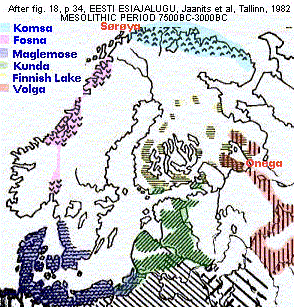
The following map depicts actual archeological
discoveries of "archeological dialects" among the ancient peoples who
were all essentially dugout or skin boat users. The graphically
patterned areas represent locations where remains of a particular
"culture" have been found. The map described the period of
between 7500-3000BC or 9500-5000 BP (before present). This is the
period of boat-peoples expansion. Note the hatched area at the bottom.
At that time it would have represented a culture that lay in the
Vistula water system and upper Oder. Note also another hatching for the
Dneiper. Later archeology reveals the entry of agricultural peoples in
these areas, but that may be misleading. Boat peoples and agricultural
peoples can coexist as they do not interfere with each other's sense of
territory. Moreover people tied to settlements and farm fields would
welcome the service that the nomadic boat peoples offered, such as
trade. Here too there are models in recent North America, in the
relationship between the farming Indians, the Hurons, and the
seasonally nomadic boat/canoe peoples, the Algonqians.
THE
OCEANIC TRIBES PATTERNS ("Komsa", "Fosna")
The patterns followed by oceanic hunters are
more mysterious. They may not even have had annual cycles, only meeting
other bands every five years or so. The Shetland Islands lore speaks of
a people they called "Finns" who were estabished for a few years on its
northern islands, and then disappeared.
Existing Shetland traditions speak of
a people called Finns
who inhabited Fetlar and northwest Unst for some time after the Norse
occupied Shetland. This name is identical with the one by which the
Norse knew the aboriginals of northern Scandinavia. It was aso the name
given by Shetlanders (of Norse lineage) to a scattering of Inuit [?]
who, in kayaks, materialized amongst the Northern Isles during the
eighteenth century. . . .In any event, Shetlanders used the same name
for these small-statured, dark skinned strangers that their ancestors
had given to the people who preceded the Norse in Shetland. (F. Mowat, Farfarers, Toronto 1998)
Farley Mowat, quoted above, advanced a theory
that original British who he called "Albans" endured in the Northern
Isles, and hunted walrus, travelling all the way to the coast of
Canada. In my theory there were always two types of boat-peoples in the
British Isles, the original dugout-using interior hunter-gatherers who
were orientated towards the east, became traders, and the skin-boat
oceanic hunters that came down at an early time from the arctic
Norwegian coast, and always remained sea-hunters, much like the Basques
further south.
If there was a circling ocean current, like
there was north of arctic Norway, and also between Norway, Greenland,
and Iceland, the movements of the oceanic hunters might have gone with
the current. The collective tribal meeting place would be in the
mid-point somewhere. For example the location where the "Komsa" culture
settlement was found, in north central Norway, would be on the edge of
a cycling current.
The evolution of oceanic tribes and ocean
expansion will be described further later.
THE
SEQUENCE OF EVENTS SINCE THE ICE AGE
In the prehistoric beginnings, as the great
ice sheets of the Ice Age retreated, populations would
have continued to grow as long as the climate was warming. When the
glacier, which was centered on the mountains of Norway became small,
climate change had slowed down. The populations of boat peoples
stabilized. They had expanded as far as nature allowed, and now they
settled each into their water basins, and each tribe started to
dialectically change within their territories because there was little
communication across water basins. These small changes are reflected in
archeology.
We know that boat people went into the
Volga, because three of the Finno-Ugric language families are accessed
by getting onto the Volga. What is unknown is the situation in the
Dneiper and other rivers draining to the Black Sea from the Baltic
direction. Languages originally there have vanished.
 Map 2: Boat Peoples Are
Partitioned By Water Systems
This map, based on geography of
rivers, roughly suggests regions where water systems tie tribes
together. The main criteria is rivers flowing in the same direction
towards a sea. This information is important in understanding how
languages and archeological data changes. The coastlines and
river orientations also suggest the directions of expansion of
boat-using peoples.
Map 2: Boat Peoples Are
Partitioned By Water Systems
This map, based on geography of
rivers, roughly suggests regions where water systems tie tribes
together. The main criteria is rivers flowing in the same direction
towards a sea. This information is important in understanding how
languages and archeological data changes. The coastlines and
river orientations also suggest the directions of expansion of
boat-using peoples.
As I said above, while humans could devise a raft of
some kind probably
even 50,000 years ago, they were basically land-people and the
development of the design of the boat, the manner in which one
travelled and hunted, etc had to be a slow process. It may have taken
1000 years or more to refine the dugout boat, determine what to hunt
and fish, develop new tools and techniques, etc. Those that had better
ideas were more successful. It was thus Nature that gradually selected
the people and methods that worked best. More successful methods
resulted in more children, more population growth, more expansion. We
must not picture a sudden invention of boat use, and a sudden
expansion. It could have, by chance, begun in one place, and
expanded from there.
The population growth in the beginning
when the people had
not figured out their new boat-oriented way of life was probably nil,
then as their methods improved there was slow population growth and
then a faster one, until the boat-culture had reached its final optimum
form. For example early dugout canoes were probably crude cavities in
logs, but in the end they were the sleek, thin-hulled, designs such as
are still created by the Khanti on the Ob River. Once the boat was
developed, it could endure by imitation. It is far easier to imitate
than originate. (In the world of art, any capable artist can make a
copy of the Mona Lisa, but only Leonardo da Vinci created the original.)
It would have been a process that took
at least 1000 years, probably 2000. Perhaps the crudest boat people,
making only a hole in a log, and stumbling about as best they could,
began in 10,000BC. Perhaps it wasn't until about 8,000BC that the new
way of life in a watery landscape had reached maturity and dramatic
expansion began.
The idea that a boat-culture does not
happen unless Nature imposes pressures forcing humans to make it
happen, or that it does not happen overnight, leads us to ask whether
boat peoples in other parts of the world were independent evolutions,
or whether they all acquired the basic culture from the boat people
under the north European glaciers. We have already touched on this
earlier. Since humans are land-creatures, the development of a
boat-oriented way of life required strong pressures to force humans to
act against their instincts.
I have referred to the Inuit (Eskimo) of
arctic Canada. Their boats were made of skins and included a one-person
craft called a kayak and the other a large vessel that would carry an
entire clan, called an umiak. To their south in the subarctic forests
there were the Algonquian boat-using hunter-fisher-gatherers who
travelled up and down the rivers. They included Cree, Ojibwa,
Algonquin, Montagnais, Innu, etc. Their boats were made by covering a
frame with birch bark. The birch bark canoe can be viewed as a form of
skin boat. Algonquian peoples towards the south along the Atlantic
coast also demonstrated dugout canoes and skin boats using moose-hide.
Were these boats independently developed or did the prototypes come
across the North Atlantic? There are many similarities between the
culture of the Algonquians and what is found in Finno-Ugrians. This
question calls for further discussion in another article.
Skin Boats and
the Oceanic Boat People
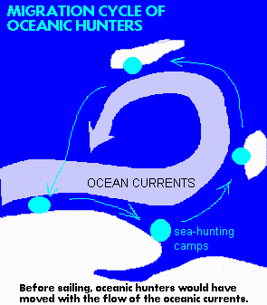
Since humans were not naturally inclined to live on
open water, I believe that boat people began as the dugout peoples who
stayed close to coasts and within rivers and marshes. Peoples who
sailed into the oceans and seas
developed a little later. For example evidence of boat-people off the
coasts of arctic Norway, does not really appear until about 4000BC.
Currently archeologists have rationalized that they came there by
coming up the Norwegian coast. By why would they travel north in ocean
waves along a forbidding shore with glaciers in the distance, when
there were plenty better places to go? This and other similar common
sense arguments suggest that the original sea-hunters of the Norwegian
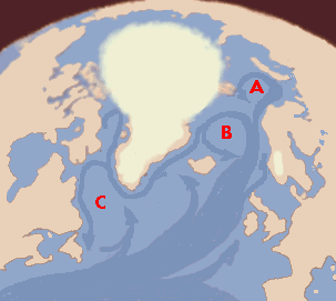
coast came from the east, via arctic Norway. See MAP 2 which shows how
the regions around the White Sea and Kola Peninsula were ice-free. What
group of people would have travelled north along a glacier coast, with
nowhere to land?!
Once the sea-hunters were
estabished in arctic Norway, and the glaciers had exposed the shore,
approaches were also possible from the south. We are here
interested in the beginnings. If we consider the beginnings, that is
the first boat-peoples in the Norwegian arctic, then we have to
conclude they came from the east over top of Norway, from around the
White Sea. Then that opens another question - how did they get to the
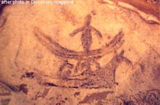
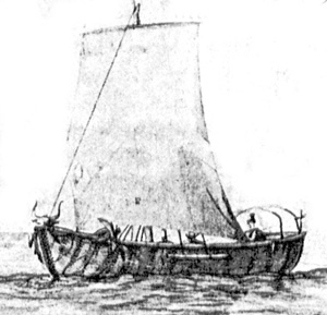
White Sea? The answer is clear in the rock carvings at Lake Onega. They
show a skin boat made of moose hide, with the head on the prow. Rock
carvings in arctic Norway include examples of exactly the same boat-
with moosehead. Since moose does not live in the arctic, the people who
used them must have originally travelled to the arctic coast from
someplace towards the south.
The next question is, how did they get to Lake Onega?
There are many reasons to believe that
oceanic hunters of arctic Norway originated from the east, from the
White Sea, and Lake Onega. Humans do not adapt to
something that is as unnatural as dealing with the open sea very
easily. There had to be strong
pressures forcing boat people to take into open ocean waves. Such
pressures would have existed in the north where food density was low.
Thus, I believe that the original
boat-people on the coast of arctic Norway came by way of the White Sea
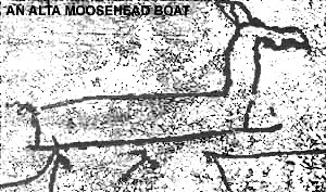
in skin boats. Rock carvings found at the Norwegian island of Sørøya,
show images of a light dugout, too small for ocean waves, but also a
high-prowed vessel with a moose-head prow ("moose" is an American word
of Algonquian origin for what is "elk" in British English). I believe
that this moose-head boat was a skin boat made from the full hide of a
moose, slit along the back, frame inserted, leaving the head attached
for spiritual reasons. These people obviousy also had dugouts, but,
like the Khanti dugouts, were too small to navigate in open seas.
Possibly the Inuit kayak , which enclosed the top to allow waves to
break over the top,
was in effect an adaptation of the tiny one-person northern dugout, to
deal with high waves and could be built without need for any tree.
If the boat was made of a moose hide, it
meant the people had to winter in a place with moose, in the forested
zone. It is common sense that since the arctic was cold and dark in the
winter, early visitors
to the arctic did not stay there through the dark winter. They all
returned to a more southern place. Lake Onega was an ideal wintering
place for boat people dealing with the White Sea and beyond. It was
also a place to hunt moose and make more boats.
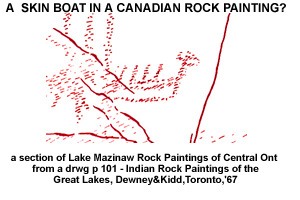
It is therefore significant that rock carvings
of the very same small-size moose-head boat that was found in arctic
Norway at the island of Sørøya has been known for a long time at the
famous carvings at Lake Onega. See information box below:
What is peculiar is that some of the rock
carving images at Lake Onega
show
sea-harvesting activity that would only occur in the arctic ocean, not
at Lake Onega, as if they
were picturing last summer's activities.
One
image, for example shows the catching of a seal. Meanwhile, the
Sørøya carvings show images of forest animals, as if when there, they
reminisced about their other home, their winter home.
Archeologists have puzzled why the Sørøya carvings do not show their
activities at that location, but forest animals - the answer is
obvious: homesickness. They must have divided their time between
summering on the arctic Norwegian coast and wintering in the forests
such as at Lake Onega.
In the annual cycle of nomadic
hunters, entire
bands, including women and children, moved together from camp to camp
and they did not have to return to the same place until the next year
(or whatever the length of their nomadic circuit.) Thus they could all
move six months away from their wintering location, and six months
back. In actual fact, the time distance from Lake Onega to the warm
waters of the Atlantic Drift, was about a month or so. We cannot
underestimate the distances humans will travel on the ocean,
considering that in the 16th century Basque whalers were regularly
crossing the Atlantic in sailing ships to harvest whales off the
Canadian coast.
The next stage in the evolution would obviously be
that some groups decided not to go back into the forest, but to remain
in the north, biding their time in the dark until the sun returned.
This would have been possible if they had caught enough meat to store
for winter use. In the winter it would not spoil. They may also have
interracted with interior reindeer people and copied their ways of
dealing with the dark winter. It is this interraction that from both
intermarriage and cultural sharing, I believe produced the Saami
- linguistically Finnic, but displaying genetic roots (esp among women)
from the east (ie the Samoyeds), and reindeer harvesting practices.
Those who thus remained in the north -
producing the archeological "Komsa" culture - were lacking moose in
their environment, and they now made skin boats
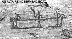
from reindeer or walrus hides. The moosehead disappeared from the skin
boat, replaced by either the reindeer head (as seen in Alta, Norway
rock carvings) nor walrus head (something found in the traditional
Alaska Inuit large skin boat called the umiak)
These people, no longer returning to the White
Sea or
Lake Onega area, with success and population growth, were able to
migrate further in search of new
sea-hunting places. Some breakaways, would have migrated south to the
outer islands of Britain becoming ancestral to the seagoing "Picts" who
history
records having skin boats. (We must not confuse the aboriginal short,
seagoing "Picts" with the "Picts" history defined as peoples settled in
northern British Isles before the Celts arrived who were probably
original British from the dugout traditions.
The eastern and interior parts of Britain
would already have been established with the original dugout-boat
peoples and traditions, but the seas had until that time been an empty
niche.
After the skin boat seafarers, the "Finns",
had spread through the outer and western parts of
Britain to harvest a branch of the Atlantic Drift that turned towards
the northern Isles, then perhaps some migrated further south, possibly
ending up as far
south as Portugal, possibly inspiring the legends of "Atlantis". They
would have become the founders of the Atlantic "Megalithic" culture, a
culture that built hill-tombs and alignments of large rocks not far
from the coast (meaning they were a people who followed coasts). The
"Megalithic" culture, as some scholars have called it, gradually spread
up the western European rivers establishing the culture throughout
western Europe. The key question as to where the migrations went
relates to the ocean currents and sea-life they harvested. In the
north, the bountiful places were located where the North Atlantic Drift
(originating on the American side as the Gulf Stream) came up to the
west of Britain, past the northern Isles, with a branch turning
eastward between the northern Isles. This ocean current then
headed towards arctic Norway, passing the Lofoten Islands, and into the
Norwegian arctic islands.
No oceanic peoples did not wander just anywhere.
Therefore one must wonder what reasons they would have had to go south
along the Atlantic coast of Europe. There are two answers - a whaling
people who followed whale migrations south, or eel harvesting people.
Eels originated in the Sargasso Sea and crossed the Atlantic, and
migrated through the North Sea and the Strait of Gibraltar. Where there
was a bottleneck, the eels were plentiful. Another bottleneck was at
the Jutland Peninsula. It is thus possible that the fabled
Atantians were "Eel People" and may have had early contact with the
Americas via a route similar to the one followed by Columbus. Even
though the "Atlantian" story is speculative, the oceanic sea people in
the British Isles, and the archeological evidence of a "Megaltic"
culture on the Atlantic coast from Portugal to the northern Isles of
Britain, and even as far east as the Jutland Peninsula, tends to
support a theory that there were an "Eel People". But this would
date back to as much as 6000-4000 years ago. (They could also
have originated out of dugout peoples just as well.)
The story is clearer about the others of the arctic
Norwegian
sea-hunter traditions, who migrated across to Greenland and Iceland and
further, becoming the archeological "Dorset" culture of the Canadian
east arctic. Canadian archeology reveals the "Dorset" culture has
affinities with northern Norway archeological culture, and had expanded
east-to-west across the Canadian arctic reaching the location where
later a "Thule" culture started coming back the other way. (Was "Thule"
ethnically a daughter to "Dorset" or the original White Sea culture
coming to the Canadian arctic having travelled in the other direction
over top of Siberia?) The "Dorset" culture appeared around 3500 BC,
which coincides with the time of the "Komsa" culture that stayed in the
Norwegian
north instead of migrating north-south. Conclusion: The "Dorset"
culture arose from the "Komsa" culture of arctic Norway.
It is reasonable to assume that the earliest
migrations were current-dependent. Reading the currents would let them
navigate well and less effort was needed. Knowing the currents, if they
did nothing but drift,
they would end up back in familiar territory. Later sailing away from
the currents
complicated matters, because the sailors were now departing from the
rock solid patterns of ocean current, and dealing with less certain
behaviours of the wind. For that it was necessary to develop
navigations skills that ascertained position with the help of counting
the days and looking at the sky. That came later. The following map
shows the manner in which oceanic peoples would have spread from the
White Sea area, westward over top of Scandinavia and then, with
success, continuing into empty niches in the ocean. As in the case of
the expansion of the original dugout boats, we assume that initially
the oceanic environment originally has no humans, so that expansion
from the arctic Norway region is unopposed.
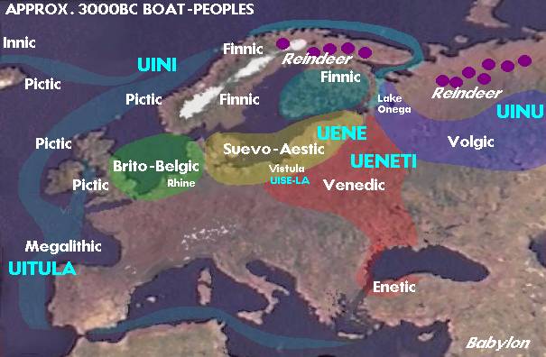
Map
3. Suggested Groupings of Boat Peoples
The map above
develops further from the previous map which depicted the initial
expansion of the dugout boat peoples. This map primarily adds the
expansion of oceanic people using seaworthy skin boats (lighter blue).
It also proposes some specific zones of the original boat peoples. Some
explanation is needed: "Brito-Belgic" refers to boat peoples around the
coast of the North Sea and into the Rhine. The gathering place for this
tribe would have been the Rhine; "Suevo-Aestic" refers to the south
Baltic zone, that in later history was occupied by the tribes the
Romans called Suebi or Suevi, and the Aestii of the eastern coast (both
of which were originally Finnic). Their major congregating site for
them was at
the mouth of the Vistula. Archeologically speaking, the Maglemose
culture, associated with the earliest boat peoples, would include both
the "Brito-Belgic" and "Suevo-Aestic" zones. Archeological study would
also identify a "Volgic" group, whose extent reached up to Lake Onega,
and interracted with the Finnic groups at Lake Onega. (Interraction of
several cultures is evidences by overlap of artifacts in the same
area.) Archeology has also confirmed a "Megalithic" culture that went
from Portugal, up to the British Isles and by 2000BC also across to
northern Denmark. The only speculative detail in the map is the choice
of calling the people who occupied rivers that drained from the north
down into the Black Sea as "Venedic". See the next section for some
comments about "Venetic" traders that developed from boat people
exploiting their familiarity with boat travel for trading purposes.
The evidence that the main base for the expansion of
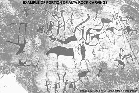
oceanic boat peoples was at Alta, Norway, is indicated by a great
abundance of
rock carvings have been found there including images of men harvesting
the
sea in boats with both moose heads and reindeer heads. There are also
images of hunting reindeer from boats as they cross water.
This region
of Norway has been the traditional home of the "Finns" and northern
Norway was called "Finnmark" (just as the region Sweden claimed that
was inhabited still by natives, was called "Finnlanda") The term "Finn"
used in the Germanic languages of historic Norway and Sweden, was a
term that generally referred to the aboriginal peoples of Scandinavia.
This included people who hunted in forests, harvested the seas, and
tended to reindeer herds. The first two - the seacoast people and the
interior hunters - were truly of boat-people traditions. The third
group, the one who tended to reindeer herds and who today refer to
themselves as Saami are and were a little different, in that they were
not boat peoples. Indeed their reindeer-dependent culture obviously
originated from the same ancestal reindeer people as the Samoyeds
towards the east in arctic Russia. What happened? I think it is a very
simple matter. Originally arctic Scandinavia only had the reindeer
people in the interior, following their reindeer herds. And then around
6000 years ago, with the development of the skin boat, and the
discovery of
harvesting the ocean off arctic Norway, boat people moved in, first
staying seasonally, and then staying permanently (ie Komsa
Culture). A situation developed (looking at the Komsa situation),
in which sea-harvesting skin-boat people, were found along the coast,
and reindeer people in the interior. Because they each had different
ways of life, they were not competitive, and contacts would have
developed between the boat people and reindeer people as long as each
respected the other's sense of territory. In the large
spans of time, the two groups would have merged through intermarriage,
resulting in the Saami. The modern Saami clearly reflect their
mixed origins. On the one hand they maintain reindeer-management
traditions that are very ancient, and on the other hand, their
appearance is quite European now, and their language is so Finnic in
character that it has been included in the Finnic languages.
Unlike some scholars, I don't find the origins
of the Saami to be a particularly complicated problem. Common sense
says that originally there must have been reindeer hunters following
reindeer herds, who originated from the same stock as the Samoyeds to
the east who also still maintain reindeer. And then Finnic boat peoples
came up from the south, and eventually many stayed there, to intermarry
with reindeer hunters. This did not happen towards the east, in arctic
Russia, because the expansion of the Finnic skin-boat peoples was
biased in the westerly direction where the warming Atlantic current
nurtured an abundance of sea life in arctic Norway. However in the
east, when the boat peoples went north from the Volga into the Kama, it
is possible that there was intermarriage and cultural exchange there
too, with the reindeer hunters, but to a lesser extent, and the
Ob-Ugric languages may be more Samoyedic than Finnic.
Of particular interest is that geneticists have
found that the mtDNA
among the Saami, that is carried only along female lines appears to
have affinity with that in Samoyed women - which would be
consistent with the boat peoples males taking reindeer people women as
wives whereas the reverse (reindeer hunters taking boat-people wives)
would not be true. Reindeer people men might not find women who knew
how to clean fish to be very useful.
The Boat-People And Farmer/Herders
During the great expansion of boat peoples, all the
rivers that emptied
into the northern seas were highways that could be used to travel
into the interior of Europe. As the boat peoples paddled up the rivers,
the waterways became smaller, and soon they were prevented from
continuing where the creeks and springs were too small for boats.
Unless they wanted to drag heavy dugouts through the forest to the next
water system, they did not go further. However there were some places
where entering another water system that drained south was easily done
from the northern water basins. One example might be the transfer from
the Rhine to the Danube.
But the easiest southward flowing
waterway to enter from the north was probably the Dneiper. Rivers
draining into the Baltic and rivers draining into the Black Sea seem to
have shared source waters, the same marsh areas. Thus it is valid to
propose that the boat people originally occupied the entire region from
the Baltic to the Black Sea (shown in Map 3 as "Venetic") Note that the
Dneiper and rivers like the Bug and Dneister, all flowed to the Black
Sea. One of the implications of this is that boat-people on these
rivers were most inclined of all of the boat people to make contact
with the farmer-herder peoples and their civilizations in the south
around the Black Sea. For this reason, I believe that they were the
origins of the Venedi/Veneti
who appear in Homer's Iliad as the "Eneti
of Paphlagonia", the region on the south coast of the Black Sea, on the
west side. They came to the aid of Troy. Troy's location at the entry
to the ancient Hellespont by which ships sailed from the Mediterranean
to the Black Sea, is good reason for coming to its aid, if the Eneti
were traders.
It is because boat-people in the Dneiper, Bug,
and Dneister had easy access to the Black Sea area and the developing
farming civilizations there, that I have covered these river water
basins with the "Venedi" designation in the above map. Volga too was
used for trade: the Volga flowed into the Caspian Sea but one could get
from the Volga to the Black Sea. as well.
Obviously, southward travelling boat
people encountered land-people in the south engaged in farming
activities. But there would not have been any conflict in their
meeting. It is important to bear in mind that boat-people and
land-people can co-exist because they live in different environments
and economic activities . On the other hand. hunting people
fought
hunting people over hunting territories. Farmers fought farmers over
farmland . Fisher-people fought fisher-people over fishing ground.
Reindeer people fought other reindeer people who attempted to take an
animal from their herd.
But people in different circumstances from one
another had no basis for quarreling. In North America, the native
hunter-fisher-gatherers of the wilderness were never directly in
conflict with the European settlers. Still, they came to an end
passively by the settlers cutting down the wilderness when they made
farmland. It is interesting to note that the major objecttions to
the arrival of settlers came from the Iroquian Natives, who were
themselves farmers. The Algonquian hunting peoples had less conflict
with settlers - until the settlers destroyed the wilderness.
Moving from the Black Sea towards
the
Vistula it was a very marshy landscape, not very attractive to farming.
But going north beside the Dneiper one found high ground. It was
over such high ground that , later in history, farmer-herders moved and
settled, in several
waves, the last wave being Slavs pushing out the Balts of an earlier
wave. Other
expansions followed the central European highlands towards the region
now Germany, as well as south into the Alps.
Thus peoples living in their separate economic
niches, co-existed. They did not need to dominate the other as would be
the case if the two had been similar, trying to claim the same economic
niche.
But in the long run, after many generations, the two
dissimilar
peoples could combine the best
of their two cultures and produce a new one that was superior to the
original two. (I have already discussed above the obvious merging on
boat peoples and reindeer peoples in arctic Scandinavia, giving rise to
the reindeer Saami.) But it would only develop if the combined culture
was better than the original ones in their pure form. The resulting
mixed culture, if it were more successful, would produce more offspring
and crowd out the older distinctive cultures. The ethnicity, the
language, of this mixed culture would depend on which tradition was the
most important in the way of life, forming the core of the mixed
culture. In the north Baltic area, for example, the successful result
was a combination of hunting-gathering-fishing plus a settlement with
limited farming, plus trading. A little of everything.
In other instances, the pure original culture
was the best, and two different peoples would endure side by side. An
example would be the boat-oriented trader whose nomadic life on water,
was so opposite to that of the farmer, that any compromise would reduce
the ability of either to do their job well. It may be the reason the
Saami have survived among all the aboriginal peoples of
Scandinavia while the rest - seagoing and interior "Finns" - have
become absorbed into the Norwegian and Swedish fabric.
Extent of Expansion
of Boat People
So far we have been looking at Europe and the north
Atlantic. There is
no question that the boat-peoples expanded everywhere that their boats
woud take them.
Fig 18
This map of the world ocean currents suggests the paths of oceanic
migrations. The most applicable currents are those that follow coasts
as then the seafarers can land to replenish supplies. Note that when
the world is shown in a rectangular fashion the top and bottom of the
map stretches the continents. In reality distances in the arctic are
much smaller than they appear here. See Figure 9 above.
OCEAN CURRENTS AS HIGHWAYS
The most interesting observation that can be made of
the above current
map, is that once there were boat capable of ocean waves - and the
arctic skin boats fit that requirement - migrations throughout arctic
waters was easy as land was close together. The notion that there were
contacts by boat, between Europe and North America via the North
Atlantic, or between east Asia and North America via the North Pacific,
at the earliest times, is so obvious that one wonders why it has to be
debated. If we show that there are certain words in common between
Finnic languages and Inuit language, should we be surprised? And yet,
scholars feel it is controversial and not obvious and needs to be
debated. In my view, this theory, as presented
here, should not even need to be a large issue. It is so obvious.
All we need to do is to establish that there were seaworthy skin boats
in arctic Norway some 6000 years ago - and this is clearly evidenced in
rock carvings; that there were people who harvested the sea; and that
there were sea currents that would have helped men in such boats to
venture towards North America into the North American arctic and down
the Labrador coast. Every requirement is present.
It is true there may be a need to
debate crossings through the centers of the oceans. Even oceanic boat
peoples tried to remain on courses that brought them to the shore where
they could find fresh water and food..
Crossing the centers of oceans and not seeing land
for weeks
would required plenty of fresh water on board, as well as food.
Did Polynesians cross the middle of the Pacific? Did sea peoples from
the Iberian coast cross the middle of the Atlantic to visit the
Bahamas? Were the latter "Atlantians"?.
There is plenty to debate
when we consider crossings through large spans of open water. But there
is no reason to debate the prospect of seaworthy skin boats following
the edge of sea ice, the coast of Greenland, and allowing ocean
currents to carry them. It is obvious even without plenty of additional
evidence.
Following the northern coasrts, there was plenty
of places to land, to fetch fresh water (or freshwater snow), and to
procure food along the way. There was nothing to hinder circumpolar
adventures if there were men with an adventurous spirit (or indeed, men
who got lost, but were still able to survive off the land and
sea.) The idea that ALL original arctic peoples were basically
the same people, from the same origin, should be an established obvious
fact in our body of knowledge. There is plenty of additional
evidence in folklore and technology - where we see parallels for
example between the Inuit and arctic Asians.
OTHER
DIRECTIONS OF TRAVEL
We have focussed on the evolution of boat
peoples in northern Europe and their expansions, including by sea
across the North Atlantic. However, they certainly also travelled
across the top of Siberia, and down various rivers that drained into
the arctic. We need to look closely at the large rivers that feed
into the Arctic Ocean. The Ob River system still has Finno-Ugrian water
people on them - the Khanti. They still have dugouts, and their
traditions speak of long trade journeys into Mongolia and northern
India. The Hungarian language is closest to them, but how the Hungarian
language came south to where is is now has not been considered to any
great extent.
To the east of the Ob, is a similarly large
water system, the Yenisey. Together the Ob and Yenisey hold a vast
region of swamp where water-people could have flourished. Does
this explain the similarities between Finno-Ugric and various "Altaic"
languages such as Turkish? Boat peoples could have easily
travelled as far as the Altaic mountains.
The third major northward-flowing river is the
Lena. It reaches south to the vicinity of Lake Baikal. Also, at the
curve of the Lena, the tributaries are such that it would not be very
difficult to cross over to the Pacific, if a water people every tried
it. The Lena River has produced interesting rock carvings and paintings
depicting people in boats who were very interested in moose (British
"elk"). This too is a subject for further study, especially since the
rock carvings and paintings bear similarities to ones already
described, in Alta, Norway, and on rock walls in northern North
America..
ASSOCIATIONS OF BOAT PEOPLES TO THE LINGUISTIC LANDSCAPE
The story so far is what is revealed by
archeology.
But how does it relate to the linguistic landscape?
Today, the regions where the Maglemose Culture began -
Denmark,
Britain, the shore between them - have Germanic languages. These
languages were imposed by Germanic military conquests occurring during
the Roman Age and a few centuries afterward. The original pre-Germanic
language is unknown, except that Swedish and Norwegian histories speak
of "Finns" as their aboriginal peoples.
While for many decades modern
scholars have tried to separate modern Estonians and Finns (speakers of
Finnic languages) from the "Finns" of historic Scandinavia, even though
Sweden ruled the region now Finland and had called it Finnlanda.
Somehow it was assumed by naive scholars that somehow the modern Finns
were immigrants and the real Finns were identifiable with the Lapps,
formerly known as Finns, today known as Saami.
But since the Saami language is close enough
to Finnish to be
classed as a Finnic language, it has always made most sense that
the
entire
Finno-Ugric languages across the north as far east as the Ural
Mountains has the boat peoples
at their roots. This is supported by plentiful mythological and
cultural imagery connected to water, water animals, and journeying in
boats. The disconnect in the scholarly world was caused by a quite
erroneous theory invented and promoted by late 19th century linguists,
as I mentioned above. Those linguists could only observe
similarities
and differences between languages and establish linguistic distances
from one another. Back then linguistics was fond of creating language
divergences from migrations and describing them as family trees with
plenty of branching. Linguistics did not know how to deal with natural
continuous adjustments between established neighbouring languages or
dialects, which includes continuous convergences and divergences at the
same time according to contact patterns. Without any archeological
information at that time about the expansions out of Europe, these old
linguists failed to consider similarities between Ob-Ugrian and
Samoyedic could have been the result of convergence (from contact,
intermarriage, trade) and not divergence from a common ancestor. These
old linguists also assumed the family must have begun at the Urals
because the peoples at the Urals were primitive whereas those at the
other end, the Estonians and Finns, were civilized. How would it look
if the theory placed the origins with the Baltic Finnic peoples?
The old linguistic theory is something like Britains
myths about
original Britain being founded by a great invasion by Celts, before the
Romans. No other science supports it, and yet back a century ago
the
idea became so entrenched it cannot go away.
To summarize: the boat peoples expanded to the Urals
from the
Maglemose and Kunda Culture. The proto-Finno-Ugric language family was
established throughout. Because boat peoples were somewhat confined to
river systems, they had a little less contact with those in other river
systems, and this lack of contact allowed more divergence than
convergence and each water system developed its own dialect. As time
went on and the peoples within the water systems settled down, stopped
being so mobile, the dialectic region broke up into several internal
dialects and eventually we had what we have today - Finno-Ugric
subfamilies each defining water systems - Ob-Ugrians in the Ob River,
Permic speakers in the Kama River, Volgic in the Volga, and Baltic
Finnic currently around the northeast Baltic. Some Finno-Ugric
languages have disappeared. If it originated ultimately with the
Maglemose Culture, then in earlier times these languages were found in
Britain to the east Baltic as well. For example, native British could
have been Finno-Ugric. Denmark and the south Baltic, we know, once
spoke the Suebic language which could have been one of those "Finn"
languages mentioned in Swedish and Norwegian history.
Some linguists have overcome this problem in
the original
linguistic theory by assuming the ancestral "Uralic" parent was widely
distributed not at a tight location at the Urals. Imagine if all the
reindeer peoples spoke the ancestral Uralic parent. Then the events
described above, of how reindeer hunters split into the boat peoples on
the one hand and the continued reindeer people on the other, would be
the founding event. Then the old linguistic model would be somewhat
correct, except that the beginning or the "Euralic" family would occur
in northern Europe and at 10,000 years ago, not 5,000. The "migrations"
of the old model would be the net result of continuous action over
several millenia and not singular events.
Language, culture and genetics act independent of
one another. Once
a boat people culture is established other people can copy it. Our
study is of boat peoples. Although it may lie at the roots of
Finno-Ugric culture, it certainly could be adopted by anyone, just as
once farming practices had been established any people could adopt some
of the innovations. Finnic peoples did not have to learn Indo-European
to creatre some farming behind their fishing village, and farming
peoples of Germany did not have to learn Finnic in order to make a boat
to go fishing on a nearby lake. When looking at the expansion of early
boat people, we are not concerned with the language and genetics of
these people (except that I do compare the language of distanct whaling
peoples with Estonian or Finnish to see if there is any proof that they
originated ultimately with the Kunda Culture seagoing peoples.)
SOURCES
AND REFERENCES
Because most of the theory is based mostly on commonly accepted
information, most of the information for which references are not given
in the text, come from most textbooks, etc. One book as being very
important: Eesti Esiajalugu, Jaanits et al, 1982, Tallinn. Other
special sources of data, pictures, quotes are given immediately within
the text.
author: A.Paabo, Box 478,
Apsley, Ont., Canada
2013 (c) A. Pääbo.