<<CONTENTS
2.
ORIGINS, EXPANSION EASTWARD
EXPANSION OF THE NEW BOAT- ORIENTED HUNTERS INTO FLOODED LANDS 12,000-6,000BP
Synopsis:
By
about 12,000 years ago,
the climate warming was accelerating
and the glaciers melting at an accelerated rate, so that the
lands were being flooded faster than they could drain back to the
oceans. In this environment, humans could no longer walk from place to
place because it was all bogs, marshes, lakes and rivers except for
islands of higher land where they could camp and find dry land; but
without watercraft they were stuck in those places, and that was not
sufficient for survival in that landscape. They had to develop sleek, light, boats/canoes that
they could use to go large distances. Moving in family groups, there
might be several canoes to a family, travelling from one
hunting-fishing-gathering area to the next in the manner of the
Canadian Algonquians of recent history. Every year several such
families living in the same water basin would gather to socialize and
affirm their tribe. But this way of life without effective canoes was
impossible in the waterlogged landscape, which I call UIRALA, left behind by the
glaciers. It may have taken centuries for this new way of life and the
canoes to be perfected, but once it was perfected, suddenly these
people had water highways everywhere and could move some five times
further or faster than previously walking on open tundra. This is
obvious from simply comparing a group of people moving past in several
canoes, versus walking on open ground. Thus the water that originally
threatened their existence, suddenly facilitated their accessing
all the food resources available in the wetlands, and moving from location to location quickly. This success
along with the warming climate and flourishing wildlife caused a
population explosion that promoted expansion from the Baltic Sea
origins in every direction that was available, not just taking the
Volga close to the Ural Mountains and beyond, but also via Lake Onega
to the White Sea and east to arctic Norway. This chapter describes this
expansion, The expansion is a certainty not just because the evidence
is in the archeology, but obvious from common sense: a new successful
way of life WILL expand.
The
Emergence and Expansion of Water
People in Northern Europe
THE MELTING GLACIERS CREATE A WATERY LAND :
"UIRALA"
At the peak of the Ice Age, the
glaciers
descended to the central part of Eurasia. What we consider 'arctic'
today was located as far south as the Danube valley, and the north was
ether covered with glaciers or had 'polar; conditions (such as at
Antarctica today) that was too cold to support life.
Geologists tell us
that as the glaciers developed they drew water out of the oceans and
lowered the sea level. When the climate began to warm, when the Ice Age
receded, when the glaciers melted, the sea level did not rise as
quickly as the melting because the glacial meltwater first spilled into
the land
and inland seas and it would take some time for the water to flow to
the sea and raise its level back up.
Thus there was a period of time
during
which the lands below the glaciers were inundated, and any hunters
found there would have no choice but to develop ways to travel on
water, or else be unable to access the wealth of life developing in those watery lands.
While humans could devise a raft of some kind
probably even 50,000 years ago, humans were originally basically
land-people and
the development of the design of the boat, the manner in which one
travelled and hunted, etc had to be a slow process accompanied by
continuous environmental pressures. Eventually the crossing of marshes,
and then travelling in open sea, became second nature, and was passed
down to children at a young age. In prehistoric times there were no
schools. Young people did what their elders did, and the way of life,
its customs, language, and wisdom was passed down. For that reason, a
way of life tended to remain with the peoples who passed it down from
generation to generation.
According to the records in the ground, the
Ice Age receded initially slowly, and then accelerated. For 10,000
years climatic change was barely perceptible, but then around
10,000-6000BC the warming was very fast. The reason for this is that
when most of Europe was covered with glaciers, its white color
reflected the sun's rays back into space. But as the melting progressed
and the dark colors of the earth were exposed, less sunlight was
reflected back into space, and the heat gain of the earth accelerated,
causing the glaciers to melt faster and faster until in the very last
stages everywhere the land was warming and the glaciers were depositing
their water. Water was being dumped far more quickly than it could
drain to the oceans. It was a very wet land, but the boat-using
hunter-fisher-gatherers flourished. It can be argued that the
boat-people became the dominant group
in northern Europe because so much of northern Europe, replacing the
reindeer hunters whose tundra and tundra reindeer were disappearing .
I call their watery world UI-RA-LA. It's peak of
expansion
was at about 8000 years ago. Then climatic warming slowed down
again, the glaciers disappeared, water flowed into the sea,
and things stabilized in subequent millenia. Today, the northern
Ice Age glaciers have survived only in Greenland. Greenland, thus, is a
final remnant of the glacier.
Figure 1
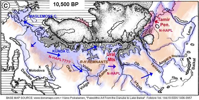
The
blue tone and blue arrows represent the initial expansion of the boat
peoples. The pink tone represents actual surviving reindeer hunters and
herds. The orange tone represents former reindeer hunters left in an
open subarctic landscape who had to hunt other animals like moose and
move around on foot as before. The boat peoples solution to
living in the flooded lands and forests was the most successful
adaptation for these conditions. Less successful solutions to the
loss of reindeer herds and the warm climate would have borrowed boat
use, just as later in history, people borrowed farming practices. Once
invented and mastered, anyone could copy. As demonstrated in Part 1,
figure 8, many reindeer people from Asian origins borrowed the
successful practices of th boat peoples, and in doing so, joined the
original boat peoples, impacting them a little genetically and
linguistically as suggested by the mixing of red and blue colours in
Part 1, figure 8
While humans were always able to invent watercraft for temporary
needs, the real revolution was the development of an entire way of life
around travelling by boats instead of walking. Walking became
restricted to the islands of higher ground where they placed their
campsites.
Gradually the former reindeer people adapted, to the flooded landscape and soon they
had access to a rich bounty
of fish, sea-mammals, and waterfowl, not to mention animals that like
water like the "moose" (American English) or "elk" (British English).
Archeology has called the two main excavations of a
boat oriented culture,"Maglemose" culture, arising from the
"Ahrensburg" reindeer culture south of what is now southern Sweden, and
the "Kunda" culture arising from a failing "Swiderian" reindeer culture
located where Poland and the east Baltic are located today. Eventually
the replacement culture in the flooded landscaoe was the "Kunda"
culture.
The expansion of the "Maglemose" and "Kunda"
cultures was the first event since any expansion into the arctic ocean
was initially blocked by the still-present glaciers. For that reason we
;look at the expansion of boat peoples east towards the Urals, before
the expansion into the arctic ocean and beyond, which began a few
millenia later.
See Part 3. for the expansion from Lake Onega, where
we see rock carvings the first skin boats with moose head prows, to the
White Sea where we see rock carvings with long skin boats with
moosehead prows engages in whaling.
THE BOAT PEOPLES: ORIGINS AND EXPANSION
According to accumulated archeological investigation
over the past century, there is no doubt that there was a major
change in way of life south of the glaciers, when tundra for reindeer
disappeared. I repeat part of the passage quoted in Part 1:
… quite suddenly, in the course of a few generations the
ecological setting changed: as Late-glacial gave way to Post-glacial
climate and glaciers entered on their final retreat, forests encroached
rapidly on the open grazing grounds formerly occupied by reindeer. …
the hunting people of the North European Plain reacted in part by
reverting to a mixed hunting economy ... but in part by developing
special skills in fishing and winning food from the seashore.” (Clark
1967: 73–74.)
The archeological culture that arose from the
Hamburgian and Ahrensburgian cultures was, as we mentioned earlier,
called the Maglemose culture . The author continues:
“The Neothermal
inhabitants of this region [North European Plain most severely affected
by environmental change at the close of the Pleistocene] had to adapt
to a landscape transformed from park-like tundra into closed forest.
. [and also depressed lands flooded with glacial meltwater producing marshes, swamps].. People could no longer support themselves hunting a single species.
... Information is particularly rich in this respect of the
Maglemosians who take their name from the big bog (magle mose) at
Mullerup where their culture was first recognized. Their hunting
grounds on the North European Plain extended in the west to eastern
England and Flanders with outliers as far as Ulster and were centered
on the marshy region now covered by the North Sea, and North German
Plain, and the west Baltic area including Denmark and south Sweden; in
the east they occupied parts of northern Russia as far as the Ural
mountains. Over the whole of this territory they were fond of camping
along river banks and lake shores on the margin of the encompassing
forest, a favoured resort of certain game animals, including notably
elk (= moose), as well as of wild-fowl, water-plants and fish.” (Clark
1967: 79.)
Judging from the locations in which the "Maglemose"
and "Kunda" cultures developed, the "Maglemose" culture would have
expanded through the region from southern Britain, through the Jutland
Peninsula, the Oder RIver valley and south through the Vistula valley.
The "Kunda" culture, on the other hand had mastered hunting animals
like seals and whales in the sea, and tended to expand eastwards
further north at the east edge of the melting glaciers. Managing to harvest large sea animals like seals and
whales, they were also responsible for the large scale expansion into the
arctic ocean coasts we will discuss later.
The story of expansion into the arctic ocean and
following arctic coast will be the subject of Part 3. Here we will
limit ourselves to the expansion of boat peoples eastward, whether we
call them "Maglemose" or "Kunda".
THE REVOLUTIONARY RESULTS OF THE DEVELOPMENT OF A BOAT-ORIENTED WAY OF LIFE
The development of the boat was intended originally
to get around in the flooded lands beneath the glaciers, but it had
further benefits. It allowed people to access aquatic food sources in
the water itself, previously in accessible. But most unexpected of all,
the streamlined canoe could travel some five times faster or further
than even on foot on flat ground. Suddenly these boat peoples were much
more mobile that any previous hunter-gatherer people.
It was such a
successful way of life that anyone in the northern landscape of lakes,
rivers, and seas who was still walking around on foot and getting wet,
would quickly copy the boat people. Any remaining pedestrian hunters,
quickly acquired boats and joined the success. As I discussed in Part
1, many of them may have been ex-reindeer peoples from Asia, who mixed
in with the peoples expanding from Europe and added mongoloid genetics,
including the N-haplogroup propogated through male descendants. (See
Part 1, for more detao; on that.)
With the
success in hunting and gathering in aquatic environments, and
travelling widely using water-highways, it is no wonder that the
populations of boat peoples blossomed
and caused tribes to divide and divide producing new tribes who
travelled further and further away to occupy the still-vacant coasts of
lakes, rivers, marshes and bogs from Britain to the Urals. It all makes
sense.
The growth of populations of boat peoples probably
exceeded the
growth of any other post-glacial hunting people. And because of boats
they expanded further and faster than any highly mobile reindeer people
on solid tundra had ever done before. A great portion of humanity today
has the boat
people
at their roots. It would explain our love for recreational boating,
canoing, and fishing. Recreational activity tends to be connected to
ancient experiences that have found themselves into our human nature.
Note that since boat-use was confined to marshes in
lowland areas, these boat peoples did not spread into highlands or
mountains. Those locations continued to have pedestrian
hunter-gatherers - these people originally pursued horses and bisons,
and would have continued, following the herds eastward as western and
central Europe became densely forested. There may be another story
about the non-reindeer pedestrian hunters, and their expansion eastward
through the highlands; but "UIRALA" is focussed on the story of the
expansion of northern boat peoples.
THE RAPID EXPANSION OF THE NEW BOAT PEOPLES FROM BRITAIN TO THE URALS
. Humans have always had the ingenuity of creating
watercraft specifically for the purpose of crossing a river or lake.
Reindeer hunters used watercraft to hunt reindeer slowed down in
crossing a river. Therefore the idea of watercraft was always there;
but until the rapid melting of the glaciers turned former tundra into
bogs, lakes, and marshes, there was no need to use watercraft all the
time simply to move around such an environment. Thus what had to be
created was not the idea of a watercraft, but a lasting watercraft that
could be used daily, and replace the traditional walking/running on
open tundra. What had to be developed was an entire new way of life.
A crude watercraft made of logs was not sufficient.
What was needed was something that could last a lifetime, survive
repeated dragging onto shores or over portages, and which would be
easily managed and move quickly. The solution was the dugout canoe. The
idea of making a boat with a skin stretched on a frame was so strange,
that its development was delayed Early dugout canoes were probably
crude
cavities in logs, but in the end they were the sleek, thin-hulled,
designs such as are still created by the Hanti on the Ob River.
Since humans are land-creatures, the development of a
boat-oriented way of life required strong pressures to force humans to
act against their instincts. The melting glaciers certainly created the
conditions in the lands just south of the glaciers as they retreated
towards Scandinavia. It is possible that reed boats may also have
independently developed elsewhere, we don't know. But in general once
the boat existed, any people who found it beneficial could copy it. In
the Mediterranean, there were ships with boat head prows, showing a
copying of a custom that originated in the north - as described
elsewhere.
It may have taken 1000 years to refine the
dugout boat to something light and streamlined, to determine what to
hunt and fish, develop new tools and techniques for the aquatic
environment, etc. Those that had better ideas were more successful. It
was thus Nature that gradually selected the people and methods that
worked best. More successful methods resulted in more children, more
population growth, more expansion. We must not picture a sudden
invention of boat use, and a sudden expansion. We have to bear in mind
that such a boat-oriented way of life - analogous to how we today have
an automobile-oriented way of life - was new. Everything about it had
to be invented from trial and error over generations, with Nature
making the decisions as to which innovations would succeed and be
supported.
The idea that a boat-culture does not
happen unless Nature imposes pressures forcing humans to make it
happen, or that it does not happen overnight, leads us to ask whether
boat peoples developed in many locations independently as a
result of similar pressures.
My opinion is that, given that imitation was easy, it is probable that
the innovation did
not have to be invented repeatedly but that it spread by imitation like
many other innovations in human history. After all, we also saw the
spread of farming, domesticated animals, and horseback riding from the
same process - an initial response to environmental pressure lasting
many generations, and finally other humans in similar environments
basically copying a practice - as humans do still today when ideas
(like using computers) take off.
Thus, we really cannot assume the boat-oriented way
of culture remained in the possession of the peoples who invented it.
As we have noted, Asian reindeer people appear to have expanded up the
Ural Mountains. Since it happened from 12,000 to 10,000 years ago
during rapid climate warmng to the Holocene, many reindeer hunters
would have given up their dependence on reindeer, and would have easily
copied the use of boats. Comparing it with today, it would be like the
spread of the use of the automobile throughout the world today.
This is important because if we look at peoples with
boat traditions today (like fishermen, traders) most of it spread from
borrowing indirectly with no genetic connection to the peoples who
originated it. For example, in our later discussions we note that there
are aboriginal peoples along the Pacitic coast today with traditions in
whaling, but archeology has revealed these people originated in the
interior and migrated to the coast. However, around Vancouver island,
the archeology suggests the peoples with whaling traditions there (in
the "Wakashan" family of languages) arrived as much as 5,000 years ago,
long enough ago for the spread of whaling from origins in the White Sea.
This reality also created some mystery about the
Algonquian languages. They are the people of the birch-bark canoe who
spread similarly through the flooded post-glacial environment but in
North America. See later, for an interesting discussion.
The Archeological Evidence of Expansion
ARCHEOLOGICAL REVELATIONS
Anyone interested in the subject of the prehistoric
peoples in the lands from the Baltic to the Urals, will encounter an
early theory of activity in the region developed in the late
1800's before there was any information about archeology. The whole
story of "Maglemose" and "Kunda" culture and boat peoples expanding
during the climate warming and glacial shrinking, did not exist. All
there was available was information about current languages and
cultures of surviving indigenous peoples of that region. So the
scholars saw nothing more than various peoples, some primitive some
civilized, and made up an entire story mainly designed around
conventions and trends in the then-new science of linguistics. So they
arbitrarily chose an existing theory by a German scholar of how
languages diverged from a series of groups breaking away from parental
groups, and migrating and linguistically diverging. In the past
almost-century, as archeology and other sciences have discovered the
truth about the rise and expansion eastward of boat peoples, and Asian
reindeer people near the Urals, and the actual events have become
clear, linguistics has failed to update the naive century-old theory of
an expansion west from the Urals.
As shown in the quote from Clark given above, this
knowledge from archology has been known for more than half a century,
but today the information about the expansion of boat peoples is still
not out there, not understood. There needs to be a good sense of the
entire picture of a rapidly warming climate, which produced a
population explosion of plants and animals, which in turn produced a
population explosion of peoples hunting and gathering those animals.
Without understanding the population explosion, the public today told
of the "Maglemose" or "Kunda" culture findings, will not see the large
scale consequences - not just the consequences of the population
explosion but also the mastery of the new way of life that facilitated
the explosion and expansion. As we will see, boat use made it
possible for humans to travel some 5 times further or faster than every
before on foot. Every river was a highway. It would have been similar
to imagining that Europe had built all its roads and highways before
the invention of the automobile.
It was an innovation with as much impact on
humankind as the development of farming towards the south. For more on
development of a new way of life, follow the link at the bottom of this
page.
ARCHEOLOGICAL FINDINGS PERTAINING TO BOAT PEOPLES EXPANSION
A summary of the revelations from archeological work
over the past century was quoted above from Clark. The actual
archeological work addressed the sites in specific locations -
generally rivers - and give them different names if there is something
noticably different in the culture as the boat peoples in that water
body introduced their own special adaptations. For example, the "Kunda"
culture of the lands to the east of the Baltic coast, present large
harpoons, indicative of hunting seals in the sea, while the "Maglemose"
culture began as a marshland hunting culture. Humans are not naturally
people who like to travel of water instead of on food, and there must
have been considerable pressure from Nature to head out into the open
sea - probably in large dugouts using three pairs of rowers and one
helmsman (since that was what archeology has found from later sites)
Perhaps the expansion of the "Maglemose" culture was
the source of the particular dialect culture on the Volga. The culture
in the Kama probably came from it, but there was some cultural
influence from Asian peoples in the Ural Mountains. North of the end of
th Kama. was the beginnings of the Pechora River. People there were
possibly ex-reindeer people who borrowed boat use, and pursued a mixure
of using boats to obtain fish, and yet keeping semi-domesticated
reindeer.
One source of information of archeological
discoveries is Jaanits et al.(see references at end). The following
presents a map - except this map does not reach as far as the Kama and
Urals. Areas labelled with the same archological name, are based mostly
on apparent continuity in aspects of the material culture. The
"Maglemose" culture appears to define a culture of marshes and swamps.
It would have expanded through all the swamplands from the mouth of the
Rhine, through Denmark, through southern Sweden, through the lower Oder
Valley, and probably southeast on the Vistula. The "Kunda" culture
appears to have adapted to the sea - hunting seals and whales - and so
this culture, naturally expanded through the open seas created from the
glacial meltwater.
Figure 6
Net result of expansion by about 6,000 years ago
showing archeological dialects of the boat peoples
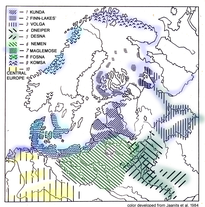
This
map shows the final results of the boat-people expansion, after the
useful water georgaphy had become inhabited, and local cultural
features were developing, In the beginning there was only the
"Maglemose" culture that expanded through the swampy lands around
southern Scandinavia, eastward to the south Baltic. Note how the
"Maglemose" hatching is shown over top of "Kunda", which indicates
mixing there - suggesting there was a multitribe gathering place there
and that "Kunda" drew from "Maglemose". Note how the "Maglemose"
and "Kunda" cultures both extend towards the Volga, from below and
above, suggesting the Volga and further the Kama (off the map) emerged
from both "Maglemose" and "Kunda" combined - which suggests they were
basically variations of the same original boat people expansion. The
map also shows the expansion of the "Kunda" culture to the arctic ocean
and its establishing "Komsa". There is some evidence that the "Fosna"
culture arose from "Maglemose" influences as the glaciers receded and
freed up coastal parts of Norway. (All hatchings in the legend refer to
boat peoples in rivers and marshes, except #10 which mixes up all
aboriginal peoples, including those in highlands of Germany)
EXPANSION OF THE "KUNDA" CULTURE
This is not intended to be an archeological paper,
but generally to present the character of archeological investigations
in the last half century.
Further informtion was publshed by Kozlowski J, and Bandi H-G 1984 (see references at bottom)
Both of the maps show how much was known by the
1980's after the wirthdrawal of glaciers and rise of "Maglemose" and
"Kunda" culture was known already by the 1960's
The following map is from that source. It is more or less
similar to the Jaanits et al map in Figure 2. This map shows the more
northerly part, so that the "Maglemose" region of the south Baltic is
not shown.
This map mostly shows the story of the "Kunda"
culture. Covering several millenia after the beginning of the "Kunda"
culture around 11,000 years ago it includes the explansion into the
north and the "Komsa" culture that probably represents the first
settlement of sea hunters who did not return south when winter
came.(See Part 3 for more detail about the expansion into the arctic)
Originally the people of Finnish lakeland, was
not there either, as it would still have been under a glacier.
So I have added to the map some colours. The
light blue shows the original "Kunda" culture (black and white vertical
hatching) and expansions from it. Archeology often fails to identify
the routes taken by boat peoples, simply because they have not (yet)
come across campsite remains along the way.
Figure 7
Net result of expansion by about 6,000 years ago
showing mainly the expansions from the "Kunda" culture (blue)
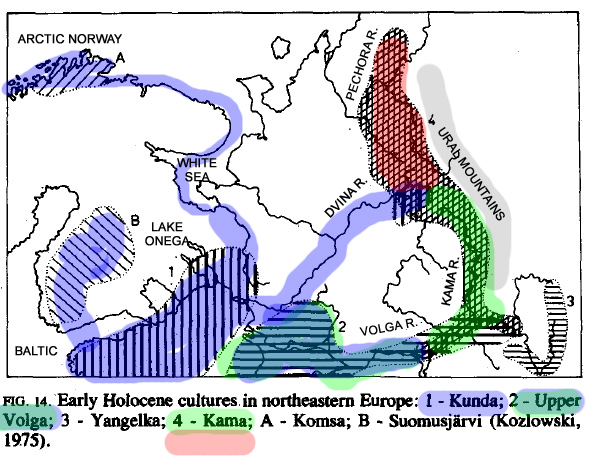
color dded to map in Kozlowski J, and
Bandi H-G 1984
This
diagram of archeological material culture zones shows the Kama and
Pechora river valleys just west of the Ural Mountains in the
crosshatching of item 4. I have coloured them green and red to suggest
the peoples in the Pechora were probably ex-reindeer people, and the
peoples in the Kama were influenced by culture of the Ural Mountains
reindeer peoples. In addition I added blue to connect "Kunda" to the
Urals, along the Dvina, and to the arctic ocean to show the Komsa
culture ultimately came from the same expansions, and across the Gulf
of Finland to the Finnish lakes (Suomusjärvi) culture. Note that
neither the Komsa culture, nor the Suomusjärvi culture could have
existed before about 7,000-6,000 before present, because the Ice Age
glaciers had not yet melted enough. The Suomusjärvi culture could have
come more directly from Maglemose via Sweden as southern Sweden became
Ice-free. But our purpose here is not to debate fine details of
archeological intepretations, but to generally show that
archeologically, the expansion of boat peoples from south of the Ice
Age glaciers between 12.000-6000 years ago was a reality
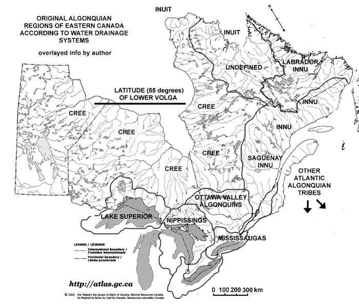
Figure 8
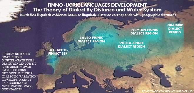
Boat Peoples Are
Partitioned By Water Systems
These maps, based on geography of
rivers, roughly suggests regions where water systems tie tribes
together. Water systems "CONTAIN" their boat peoples, and that causes
in situ dialectic divergence with boat people in neighbouring water
systems This map proposes that if the boat peoples originated
from the "Maglemose" culture, there was a region in Britain too because
evidence of dugout boat peoples has been found there too. Of
course, since all the western culture has disappeared in the last
millenium or two, it is difficult to reconstruct the boat peoples west
of the Baltic. Linguistics in particular is unable to acknowledge the
existence of any language that did not produce a descendant language
surviving today, since linguistic methodology can only analyze known
existing languages. See a similar map for northeast North America
in Figure
The Recent Algonquian Boat Peoples of a similar North American parallel
SIMILAR SITUATION IN NORTH AMERICA
When European colonization began in the
1700's, observers found in the northeast quadrant of North America a
seasonally nomadic canoe-oriented people whose way of life we can use
as an example of how the situation must have been in northwest Eurasia
perhaps as late as two millenia ago.
We can believe that the Algonquian situation had
changed little over the past 10,000 years or so because until the 16th
century, with the arrival of Europeans, they were not impacted by any
other way of life. In northwest Eurasia, particularly up the Volga, and
Dneiper, the northern boat people were drawn into the fur trade.
With strong contacts with southeast Europeans civilizations, both the
boat peoples at the north end of the Volga and Dneiper (including links
to the Baltic) were influenced from the southern civilizations. It lead
to the creation of farming and settlements, which reduced the range of
contacts between tribes, which caused the rise of smaller social units
and dialects. It lead ultimately to the entire zone becoming
"civilized" so that we can only tell the original situation from the
grouping of languages and dialects into "Finnic", "Volgaic", "Kama" and
"Ob-Ugrian" which generally speak of dialects and languages developing
within the major water systems (Baltic water basin, Volga water
basin, Kama-Pechora water basin, and Ob River water basin) which would
have developed as the original highly nomadic peoples settled down and
became dialectically subdivided.
While there are scholars who have advanced for a
century now, the belief that a dialectic subdividing occurred, as the
people stopped being far ranging nomadic peoples.
NORTHWEST EURASIA: A CONSEQUENCE OF CONTINUAL INFLUENCES FROM "CIVILIZATION" IN LAST SEVERAL MILLENIA
In northeast North America, particularly in
northeast Canada which was about the same latitude as the middle Volga
, the Algonquian parallel peoples had never been impacted before the
arrival of the European powers a few centuries ago. It is possible to
even see the first consequences of contact in the response of
Algonquian tribes to the arrival of Europeans - French and then English
- as the native peoples began making long canoe journeys of up to 2000
km, in fleets of birch bark canoes, to carry furs to the fur market set
up where Montreal is today. Had Europeans not arrive, eventually
influences from the south would have arrived. Archeology has determined
that there was trading going up and down the Mississippi (perhaps
similar to trading going up and down the Volga for millenia starting
from about 5,000 years ago ("Comb-Ceramic" culture) and changing little
for a millenium or two. The Slavic culture (today the "Russian"
culture) only arrive in the boat-people country from about two millenia
ago, and the arrival of Norse/Viking traders only arose since about
1000 years ago. But trade going up and down the Dneiper and Volga
dates back to about 5,000 years ago, as proven by archeology. (furs
disintegrate in the ground, but amber survives. The amber came from the
southeast Baltic coast, in shipments incuding furs and other northern
goods, as confirmed by findings of lost/dropped amber objects along the
route. The more recent Slavic and then Norse migration into the trade
network unfortunately became so strong, that as in North America, the
original presence of the aboriginal boat-oriented hunter-gatherers is
covered over. But today's North American aboriginal people would not be
surprised. It has only been about a half a millenium since the first
European colonization of North America, and all the original North
Americans have been reduced to a minority. Why does it happen. The
answer is simple: farming activity produces food usable by humans in
much greater concentration than wild nature - where the food sources in
the north are widely spread out in a low density, so that all
creatures, including humans, dependent on those food sources have to be
widely distributed. Thus it should be clear, "civilization"
overran the original human low density condition purely because of the
ability to procure food by farming within a land area of only as little
as 1000 square meters of land, whereas in nature in the northern
wilderness hunter-gatherers needed maybe as much as 100 square
kilometers per family to make a living.
Since in northwest Europe, the highly nomadic low
density boat-oriented hunter gatherers had been impacted by
"civilization" in the south from about 5,000 years ago, even by the
Roman Age, they were a considerable distance from their origins.
Actually those parts most impacted by "civilization" - at the east
Baltic and up the lower Volga - became progressively more
"civilized", while the remote parts of northwest Eurasia that had
little contact with southern civilization remained in their original
"primitive" way of life. In other words, the transformation was not
uniform over the entire area.
For that reason, we can get insights about the
original expansion from the Baltic, before the changes from what was
observed of the Algonquian peoples of Canada at the time of European
arrivals around the 17th century.
THE NORTH AMERICAN PARALLEL: ALGONQUIANS
The Algonquian peoples have been defined by similar
language and a boat oriented culture - mainly birch-bark canoes.
Scholars have similarly subdivided the Algonguians according to the
water systems to which they belonged. Without sharp geographical
or political boundaries, all the Algonquian peoples formed a continuum.
It was not a smooth continuum, but the boundaries of each water system
tended to confine the peoples, and even provide a natural
social/poltical subdivision.
Figure 5
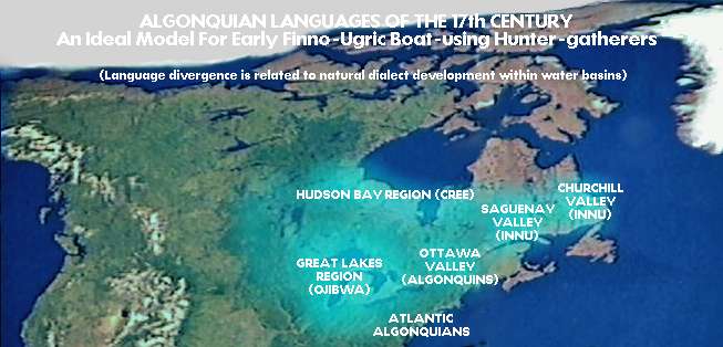 The dialectic division of the
Algonquian boat oriented (birchbark canoes) seasonally nomadic
hunter-gatherers, was shaped by the water geography
The dialectic division of the
Algonquian boat oriented (birchbark canoes) seasonally nomadic
hunter-gatherers, was shaped by the water geography
Figure 6
 The Cultural Dialects of Algonquians was determined by water geography - solid lines indicate edges of water basins
Water basins are shown by the added
lines. Like in the Ur-Finnic boat cultures of northwest Eurasia around 12,000-6,000 years ago, the social and political
organization of all the Algonquian (canoe-using) boat peoples were
determined by the natural heirarchy of water systems. The social and
political units ranged from extended families, to tribes made up of 5-6
families in a river system, and several tribes in a larger system
formed a ‘nation’ and all people of a similar language was a
‘people’ We are interested in the fact that the Cree language
formed a single language with only dialectic variation, that covers
about the same distance as the distance between the Baltic and the
Urals, thus proving that it is possible to have very broad origins,
that subdivide dialectically over time, some dialects becoming extreme
– ie languages. As described in the main text, while the ancestors of
the Algonquians were not impacted by new developments until the recent
arrival of European colonists, in northwest Eurasia, the influences
began as early as 5,000 years ago with fur trade, and then farming
settlements in suitable locations. This shrunk the scale of activity
and subdivided the original broad foundation
The Cultural Dialects of Algonquians was determined by water geography - solid lines indicate edges of water basins
Water basins are shown by the added
lines. Like in the Ur-Finnic boat cultures of northwest Eurasia around 12,000-6,000 years ago, the social and political
organization of all the Algonquian (canoe-using) boat peoples were
determined by the natural heirarchy of water systems. The social and
political units ranged from extended families, to tribes made up of 5-6
families in a river system, and several tribes in a larger system
formed a ‘nation’ and all people of a similar language was a
‘people’ We are interested in the fact that the Cree language
formed a single language with only dialectic variation, that covers
about the same distance as the distance between the Baltic and the
Urals, thus proving that it is possible to have very broad origins,
that subdivide dialectically over time, some dialects becoming extreme
– ie languages. As described in the main text, while the ancestors of
the Algonquians were not impacted by new developments until the recent
arrival of European colonists, in northwest Eurasia, the influences
began as early as 5,000 years ago with fur trade, and then farming
settlements in suitable locations. This shrunk the scale of activity
and subdivided the original broad foundation
SIMILAR POST-GLACIAL ENVIRONMENT FOR BOAT-ORIENTED HUNTER-GATHERERS IN NORTHEAST NORTH AMERICA
Figure 7
Late Ice Age in Ice America shows how
a flooded landscape appeared in southern Quebec and Ontario into which
a boat-oriented boat people could spread into.
In the story of northwest Eurasian post-glacial boat
peoples, we discuss how humans are not naturally designed to sit in
boats and travel for hours in boats. Humans are pedestrians. Therefore
adapting to a new life riding around in boats required considerable
pressure from Nature to do so. The lands had to be suddenly flooded,
where previously they had been dry. This situation occurred with the
melting of he glaciers - but especially in the Late Ice Age. As the
white of snow and ice decreased, more of the sun's heat was absorbed by
the dark earth and sea, instead of being reflected back into space by
snow. That is the reason the retreat of the Ice Age occurred slowly at
first, but accelerated so that in the last stages melting was occurring
very fast, In Europe the accelerating occurred from 12,000 years ago.
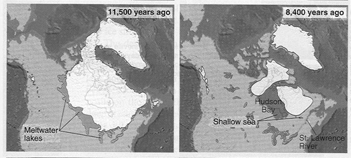
The two maps of figure 6, show the dramatic change in North America
between 11,500 years ago and 8,400 years ago. The applicable map is the
latter. The glacier had by then withdrawn enough to open up inhabitable
lands into which people could expand, as long as they were able to
navigate the flooded lands. The 8,400 map almost predicts the expansion
of Algonquian boat peoples from the Great Lakes water system out of
very low density woodland peoples.
Archeology of the North American east arctic has
determined that humans arrived there very early. Finds of stone blades
on the east North American coast that seem similar to those in Europe
has lead to theories of early crossings of the Atlantic. It is unlikely
that boats crossed the North Atlantic until there was a reason for
humans to go onto the open sea, and to become very comfortable with it.
I believe - as we see in Part 3 - that this reason arose with whale
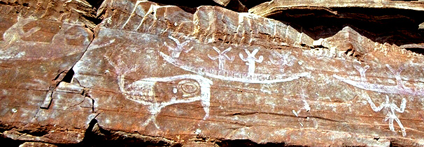
hunting. A rock carving at the White Sea shows a tribe in many large
boats catching a whale in much the same way that was used by Greenland
Inuit in the 17th century. Whaling peoples became aware of where the
whales were. They travelled up and down the European coast - which may
have taken them south and become seatrade cultures who created the
megalithic structures. It is common sense that a group may have
discovered that whales congregated at the south end of Greenland, and
that they travelled up and down the North American coast. I believe
that the Algonquian culture may have arisen from whale hunters who,
arriving at the Grand Banks, were halted by the bounty of fish and took
up residence on the coasts there. There they became salmon-catchers in
much the same way as on the Pacific coast, and followed salmon up the
rivers. All Algonquian cultures came to dominate all the rivers that
drained into the north Atlantic ocean including indirectly based on the
fact that the Great Lakes that drained to the Atlantic via the Saint
Lawrence River - except for the Cree who took up residence in rivers
draining into Hudson Bay.
The origins of Algonquians in oceanic skin boat
peoples is suggested by the design of the birch-bark canoe, which is
essentially a skin boat that employed birch-bark for the skin. Still,
dugouts were not unknown. Algonquians at the Atlantic where birch trees
were rare, and there were large deciduous trees, did make dugout
canoes.
The origins of the Algonquians can be a combination
of several influences. The reality to consider is that what happened
once, happens again, if all factors remain unchanged. If the Norse
managed to reach the Canadian coast by accident, simply from following
currents (A current would take them from northern Norway to Greenland,
and from Greenland to the Labrador coast, and then south along the
Labrador coast to southern Newfoundland, where boats will begin to face
the Gulf Stream coming against them, making it counterproductive to
continue south. Since aboriginal whaling peoples had all the same large
boats, and same currents and winds, the accidental arrival at
Newfoundland could have occurred many times over the several millenia
when whaling people were established. Of course, such people, following
whales, would not have sense being lost, because they knew exactly
where they were - on the whale migration route. (Today we orientate
ourselves to location on unmoving land. Whaling people like reindeer
people were oriented to the animals they hunted, not to a location on
land or sea.)
Thus the Algonquian boat peoples could have arisen
from both Native North Americas, and influences from across the North
Atlantic. (And we cannnot dismiss the possibility of Native North
American seagoing people, when and if they existed, from riding the
Gulf Stream from North America to Europe. Except that the Gulf Stream
ride would have to be a long one, without access to fresh water - less
probability of success than a route following currents that carry boats
along the Greenland coast to Iceland, to more Greenland coast, then
Labrador coast.
In any case, the retreat of the North American ice
sheets, opened the doors to the development of inland boat culture in
order to exploit the virgin lands freshly released from under the
glaciers. If it did not begin around 8,400 years ago, it happened
within a millenium or two later.
In any case the resulting expansion into the flooded landscape,
which was similar to the circumstances in Northwest Eurasia about the
same time, can provide insight into the nature of boat peoples way of
life, before the arrival of influences from traders and farmers. The
influences on the Algonquians occurred only a few centuries ago from
European colonists, while in northwest Eurasia the influences came
several millenia ago. North America upon European contact with it, was
roughly similar to the Copper Age in Europe.
Thus, the Algonquian boat peoples of the east half
of what is now Canada, will provide insight to the circumstances of the
northwest Eurasian boat peoples when they were still seasonally nomadic
boat-oriented hunter-gatherers. The following section enumerates some
of the insights.
The reader is asked to project this recent Algonquian canoe peoples example
into the proto-Finno-Ugric boat peoples of around 10,000 years ago. What can we conclude?
The original single proto-Finno-Ugric language between the Baltic and
Urals probably, like the Cree dialects, also had mild dialectic
difference in 3-4 steps - Baltic, Volgic, Permic, and Ob-Ugrian. The
dialectic subdivision would have occurred naturally, primarily
according to the water basins of the east Baltic, the same as in the
Algonquian dialectic subdivisions.
The story of the expansion of the proto-Finno-Ugric boat peoples is
very clear, and so is the dialectic subdivision according to major
water geography divisions. It should be so obvious there needs not be a
debate. Archeologists could use the Algonquian information to analyse
their archeological data in terms of behaviour patterns. European
scholars have not made much effort to look for examples in North
America. Care must be taken that boat people examples come from boat
peoples not from farming peoples like the Iroquoians. Iroquoians lived
in villages surrounded by farm fields. They made boats, but only for
temporary use - an example from history, of them making fresh elm bark
into a long boat, for crossing Lake Ontario. It was a single use boat,
since once dried it broke apart. Farming people did not need permanent
efficient boats to be used for years.
Insights into the Way of Life of northern boat-oriented hunter-gatherers
INTRODUCTION
Through a greater understanding of the recent Algonquian tribes across
northern Canada, we can find much insight into the way of life of
boat-oriented hunter-gatherers - how they defined territories according
to water systems, and how their social organization was naturally
defined by the heirarchy of the water geography - such as extended
families having river branches as their territoriy and the tribal
territory being the entire water system (except if the water system was
very large, in which case - like the Volga - there could be 3-4
tribes.) It is through my learning about the Algonquians, adding to it
information from "primitive" tribes elsewhere in the recent world, that
I present the following reconstruction of the evolution of the
northwest Eurasian interior boat peoples. Essentially we need to
understand natural human social and territorial behaviour, as it
manifested in particular environmental situations - in our case the
northern marshy and forested environment that was found throughout both
northern Eurasia and northern North America.
THE ORIGINAL EXPANSION INTO POST-GLACIAL VIRGIN TERRITORIES
How did population growth affect migrations and new social units?
The warming climate as the glaciers decayed - in
mostly Scandinavia in Europe, and Quebec in northern North America -
was causing the populations of wildlife to increase - the marshes
came alive with waterfowl, fish, and even large
animals like the moose. This represented an increase in both
hunted and gathered food for the humans. This new way of life
travelling in boats on water, and going much faster and/or further,
allowed humans to access wildlife that had been inaccessible while they
were only on foot on dry land. The lands and waters that had formerly
been underneath glaciers were virgin lands where no human had been
before, and therefore, their expansion encountered no previous
inhabitants - they were not entering anyone else's territory, and there
was no need to engage in territorial competition, nor was there any
mixing with existing inhabitants - except when they expanded
beyond the reach of the new virgin lands and the lands already had
inhabitants of a similar character.
The manner of expansion is easily understood, when
we understand that humans in their natural state can only grow their
tribes to a certain size before they have to give rise to new tribes
which then have to travel far enough away to be beyond the territory of
the parent tribe. If the natural tribe size is at most 80 individuals,
or 6 to 8 extended families, then there would be pressure for a group
to break away somewhere between 60-80 individuals, and set off on a
journey to new lands/waters.
(Note that humans managed to make the size of their
tribe larger by instituting government, rules, regulations and
processes for administering them. That could lead to large tribes or
many tribes consisting of many more families than 6 to 8. It gave rise
to "city states", "confederations", "kingdoms", etc."
Thus, with the rapid climate warming occurring
around 10,000 years ago, boat-people populations began to increase in
parallel to the flourishing of wildlife. Families, bands and tribes
grew large, and
daughter
tribes split off from mother tribes, and migrated far enough away to
establish new hunting-fishing-gathering territories.
Even though groups of men could travel thousands of
kilometers in a summer, and actually visit distant places, the
expansion could not occur faster than the rate of population growth.
Accordingly the expansion could not occur in a single summer. Each step
in the expansion could only occur as each parent tribe grew too large.
Nonetheless, even if we consider a birth rate of 3 adults coming of age
as 2 adults passed away, the rate of expansion would be quite large.
Breakaway groups would arise every few generations, and since the
breakaway groups needed to migrate into new virgin hunting-gathering
territories, the entire region from the Baltic to the Urals in
northwest Eurasia, or from the Atlantic to central Canada in northeast
North America, could become inhabited by the respective boat peoples
within a thousand years
TERRITORIAL POSSESSION AND SOCIAL ORGANIZATION
We can learn a great deal about territories and social organization by what is known
about the Algonquian canoe-using hunter-fishers of the northeast
quadrant of North America. from direct observation in the last centuries since European colonization.
The most important truth for scholars
to understand is that humans are territorial. You simply cannot say
that a particular people migrated into another area, without
considering whether there were already people there. It is important to
understand whether the lands, marshes or seas entered was already
someone's territory or not. If the lands were not possessed by existing
inhabitants, then newcomers could simply enter and not be opposed -
other than being opposed by wild animals like bears. If there were
already people in the destination area, then if those people used the
same resourced (such as both were hunter-gatherers), then the newcomers
would have to compete, even enter battles, to push the existing
inhabitants out. The newcomers have to be stronger and be able to
defeat the original inhabitants.
The exception to this would be if the people at the
destination pursue a completely different way of life. For
example reindeer hunters living in dry elevated lands would not
represent any territorial threat to boat peoples, as each has a
different sense of territory. People who are living off reindeer herds
at higher elevations pose no territorial threat to boat peoples. Later
in history, farmers and hunter-gatherers too were compatable. Or later
professional traders were compatable with just about all other ways of
life.
Thus competition, even wars, arose only where two
groups sought to claim the same kinds of resources in the same areas.
Thus when two peoples encountered one another in the
same geographical area, and they got along because they followed
different ways of life and had a different sense of territory, it was
important that each side respected the territory of the other. Thus
reindeer hunters did not hunt or fish in the lowlands. Or later farming
people did not pursue any hunting or gathering in the wilderness at
all. The tendency was for each side to become more strongly entrenched
in their way of life, and then secure the goods of the other side
through trade. This could be observed in recent northeast North America
where the Algonquian nomadic boat-oriented hunter-gatherers made annual
visits to the villages of the Iroquoian farmers called "Hurons" or
"Wendat". I recall reading how scientific investigation of the diet of
the "Hurons" showed that they lived almost entirely on the grains they
grew.
More recently I recall scientists were investigating
the skeletal remains of farmers and hunter-gatherers located in the
early "Danubian Culture" where a similar interraction between farmers
and hunter-gatherers took place. Some naive scholars wondered why the
hunter-gatherers remained within their culture, and did not adopt
farming ways. The answer is exactly the same - in order to get along,
each side had to be entrenched in their unique way of life, and then
trade for whatever the other had. However, if one of the ways of life
was not strong, not succeeding, the strengthening of each side did not
happen, but rather that the weak side became weaker until they had to
end their original way of life and join the winning side.
Therefore both results were possible - strong
reindeer hunting groups becoming stronger in their identity, and weak
reindeer hunting groups becoming weaker and seeking to join the winning
side.
During the rapid climate warming the new boat-oriented way
of life which was an adaptation to the new warmer environment was
strong, while the remaining reindeer peoples were only strong towards
the north as a result of shifting north with the reindeer. Towards the
south, among reindeer people who had been slow to respond, the reindeer
hunters were compromised. Thus one can pretty well predict that -
speaking in terms of reindeer people moving north through the Ural
Mountains - the reindeer peoples at the north end of the Urals around
10,000 years ago were not likely to have changed, and contacts with the
boat peoples for trade, did not alter, but intensified, the identity of
each side. On the other hand towards the south compromised reindeer
people would have changed their way of life.
Let us consider the reindeer people who changed
their way of life towards that of boat peoples. That action placed them
in a new competition with the existing boat peoples. The new converts
would now be intruding on the territories established by the existing
boat peoples. For a boat people tribe, their territory would
comprise an entire river. Archeological information suggests that the
original boat peoples had not yet inhabited the Pechora River because
of its northern location, nor the Ob RIver because of the Ural
Mountains being an obstacle for crossing by water.
Otherwise, if weak reindeer people wanted to intrude
on the territories of boat peoples, then, failing to find their own
virgin territories, they would have to win territories by
competition/battle with those who had already staked their claim on
those territories. Failing to find their own boat-oriented territories,
and losing competitions to steal some, the compromised reindeer people
would basically have to become subservient to the winner - as examples
in North American history shows, the losing side becomes servants to
the winner. That essentially means extended families acquire
unrelated members who lack inherited rights, such as they may be. In
general, slavery in humankind arose from winners of wars seeking to
make individuals from the loosing side useful. (This rise of
illegitimate people in servant roles arose with competition and war,
which began mainly in the resource-poor southeast Europe, where the
losing side was offered mercy, within the society of the winning side.
Such people otherwise lived a good life. They simply did not have
legitimacy.The evil, unnatural, kind of slavery arose when humans were
treated like a commodity, much like domesticated animals - cattle,
horses - were, which was dehumanizing.)
These would then be examples of how we should not link way of
life to language nor genetics. The expansion of the boat-oriented way
of life would not remain in its original genetics nor language.
However, insofar as language originated to describe a way of life, even
when the way of life was borrowed/stolen by another people, the
language of those other people would still be forced to import words
and expressions that were found in the language of the original way of
life, in order to use that way of life. (This can be better understood
in the historic example of hunter-gatherer people adoptiing farming -
and having to import/borrow farming related terms. Or, today all lesser
used languages of the world import technological terms from the
languages spoken by the peoples who developed the technologies.)
UNDERSTANDING THE DYNAMICS OF TERRITORIAL CONFLICT VS TERRITORIAL HARMONY
Since we are speaking also about insights from the
native peoples of recent northeast North America, we could also point
out how among the Iroquoian farming trimes, tribes on the south side of
Lake Ontario, invaded the north side in the 17th century, which was
home of the Huronian Iroquoian tribes. As the above text suggests,
vicious wars arise from peoples of a similar kind competing over the
same resouces. (In this case the resources were the furs that were
traded to the French and English entreprendeaurs in Montreal and Albany
- the southern Iroquoian tribes had trapped beavers to extinction and
were extremely jealous of the tribes to the north.) The invaders - a
"Mohawk" confederation - destroyed Huronia, and established their own
settlements along the north shore of Lake Ontario, ready to recieve
European traders. The survivors of the "Hurons" or "Wendat" tribes, of
course were unable to survive in the wild, so they became attached to
the invading Iroquoian tribes as illegitimate individuals attached to
families. Meanwhile, the Algonquians who had had close trading
tribes with the "Hurons/Wendat", were enemied to the invaders only by
association. Being mobile, they retreated towards the north, but the
point is that the Iroquoian people (a completely different culture in a
completely different way of life) really had no agenda of making war
with the Algonquians. As it happened, by the end of the 1600's, the
Algonquian tribes became united, attacked and conquered all the new
Iroquoian settlements along the north shore of Lake Ontario, and
returned south. By then of course, the "Huron/Wendat" tribes were no
more. Some remnants joined Algonquians at the north end of Lake
Michigan, and in that mixed culture, there was some permanent
settlement and farming added to the original Algonquian culture.
Anyone interested in reconstructing the distant past
of the expansion of boat peoples in northwest Eurasia and relationships
at the southern frontier with arriving farming people, studying the
native history of Ontario, Canada, will be an eye-opener. Humans are
instinctively the same and the same dynamics will be at work at the
basic level - before being distorted by complex governments and
technology. The most important truth, in my opinion, is that the way
harmony is achieved, was/is in different peoples becoming different
from one another expecially in having a non-competitive sense of
territory. As I said above, hunter-gatherers did not mind the entry of
farming peoples into their wilderness, if those farming peoples truly
stayed within their territory of growing their own food.
Similarly later, traders were not opposed by any people, if those
traders were not seen to hunt, but obtained all their food from their
trading activity. This path to harmony is similar to how in jungles,
the density of wildlife is achieved by the diversification of species
and environmental niches. A red bird with a beak for insects is not
going to go to war with a blue bird with a beak for seeds. Nature is
about survival, and survival is achieved from minimizing competition.
Humans achieved the diversification in a similar way, but using
technology.
To summarize: The boat people
originally expanded into virgin lands, but once the expansion had been
completed and tribes were claiming ownership over wildlife in different
regions, newer immigrants had to deal with those who were already
there. The newcomers could move on, or agree to take marginal lands, or
to hunt and gather other animals. For example, it is possible for an
overpopulated tribe to divide between those that hunted moose, and
those who caught fish. It depended on what the environment offered. In
later history, economic confederations might develop. For example from
about 5,000 years ago, people at the southeast Baltic initiated amber
trade with southern civilizations. A short time later the tribes there
took on specialized roles - one tribe collected the amber from the
shores, another tribe served the role of shipping the wares (not just
amber) south via the Vistula, another tribe was engaged in making the
large dugout canoes. another tribe served as merchants managing a trade
market, another was engaged in fishing, hunting, growing crops. For
that reason, Ptolemy called this economic confederation of tribes
"Venedae races" and Tacitus called them "Aestii nations". They both saw
many tribes united by a common purpose. There were other such economic
unions too in Europe, by Roman times, before the Roman Empire
reorganized it all.)
In terms of the early boat people, it is important
to bear in mind that after the boat peoples had spread from the Baltic
to the Urals, that region was basically populated, albeit
sparsely. Thus while the original expansion could cover the
entire region from
Britain to the Urals in 1000 years, further waves of migration had to
deal with the established peoples - taking marginal lands, fighting
battles over ownership, and trying to find peaceful ways of sharing
increasingly limited resources as the populations grew. They
could join the existing people by taking up residence in marginal
waterways - branches of a river in less desirable geography.
Eventually, packing more people in the area required more sophisticated
government structures to enable tribes to be larger, or to form
economic confederations of tribes that allowed a greater diversity of
territories. This is the cause of dialectic subdivision
developing, that changed dialects covering entire water systems, to the
dialects becoming extreme (related languages)
It is obvious that unless there is evidence of an
aggressive people pushing backwards, from east to west, at a later
time, that the original idea of an east-to-west migration as suggested
in the naive 1800's by linguists, could not possibly occur. However, it
is certainly possible for traders to travel up the Volga from east to
west, and be unopposed - even welcomed - as long as the traders were
clear they were only interested in trading, and not settling, nor
taking any established territory from the natives.
Different peoples could occupy the same landscape,
as long as they exploited different resources. In other words concepts
of territory could overlap in the same landscape. Farmers,
traders, fishermen, crafters could - and later did - occupy the same
environment as long as they were clear as to staying within their
territories and respecting those of the others. It is the origins of
professions. Specialization plus trade also made for a better economy
for everyone involved.
Today scholars are ignorant of such truths. For
example, today there as scholars who insist almost to the point of
insanity, that the ancient peoples called the "Veneti" spoke a
Slovenian-like language, and that any opposing idea, such as that they
spoke the language of the amber trade - Finnic - is wrong. But the
reality is that the Indo-European Slovenian-like language could
certainly have been the orginal language of peoples settled in the
mountains, and that the existence of Venetic in a completely different
language was possible too. As long as each group adhered to their way
of life, there was no conflict. The "Veneti" located in the marshy
lowlands near the northwest Adriatic coast, and the trader routes,
while the mountains and highlands pursuing herding and farming,
dominating the larger mountainous language.
Our sense of a single language covering a wide area
anc many different ways of life, comes from the creation of large scale
political nations. Until the Roman Empire there was no such large
scale government, so common today, in continental Europe, causing all
peoples to need to speak Latin.
To understand the ancient past, we have to get rid
of our modern ideas about governments, languages, cultures, and
genetics - which today are all interchangable.
Patterns of Seasonal Migrations among Boat-oriented Peoples
CANADIAN MODELS OF BOAT-PEOPLE BEHAVIOUR
In describing the boat peoples who expanded
through the region from the Baltic to the Urals (and beyond too) the
UIRALA articles often make references to the Algonquian indigenous
peoples of eastern Canada, as they were when European colonists
arrived, because they lived in a similar latitude, and similar
post-glacial lakeland, and lived by the boat (well known for their
birch-bark canoe.) What Europeans observed a couple centuries ago,
provides us with actual examples of how humans would organize their
lives if they lived on water systems and travelled in boats.
A natural human tribe consists of 5-7 bands
(extended families of brothers and sisters, their children and elders).
(Larger tribes require political organization, government, to remain as
one.) From the Canadian evidence, the most common pattern among
boat-peoples is that the 5-7 bands each 'owned' one of the water basins
of the tributaries of a large river so that the tribe as a whole owned
the entire river water basin. The extended family bands travelled through their large
territories on their own for most of the year, and then they all came
together once a year to socialize, find mates, trade, exchange news.
The tribal meeting place was usually near the mouth of a river.
For example in Canada, the Kawartha Lakes region
water basin drained south towards a lake called Rice Lake today, and
from there a river continued to Lake Ontario. There were some 7(?)
extended families, each assuming territories in one of the branches.
Every year, in late summer, all families would make their way down the
rivers to the tribal gathering place located at Rice Lake and live
together for a month. A relatively small population, thus, covered an
area, that today contains a million people. It is difficult to
fathom how after the Ice Age, a relatively small population of nomadic
hunter-gatherers might cover northern Europe in only several
tribes.
In the case of peoples who fished and
hunted sea coasts, perhaps a tribe was distributed along the coast,
each band claiming a part of the coast. Archeology shows that there was
a cultural unity along the south Baltic which they have named
"Maglemose". If the bands of this tribe travelled the coast, the
central location where the bands got together would have been at the
mouth of the Oder as it would be a central location. And on the east
Baltic the bands of the tribe archeologists have called "Kunda" would
probably have met at the Dvina (Daugava, Väina) at the Gulf of Riga.
The mouth of the Vistula would have been the gathering place of bands
who travelled the Vistula. If the three tribes wanted to meet in a
large gathering, the mouth of the Vistula was a good place. Archeology
has found overlapping of archeological cultures there. Another location
where it appears two or three tribes came together is Lake Onega.
The further north the
people live, the lower the food density in the land, and the further
they had to travel to secure their food. Thus for example the Cree
around forested part of the the lower Hudson Bay, covered a territory
as much as 3000km wide, their far-ranging movements keeping the
language from breaking into many separate languages over that entire
area. (Europeans did however note three dialects). North of them, the
arctic ocean boat-oriented Inuit had established a single language,
with about three dialects from Alaska all the way to Greenland.
Towards the south, where food density
was greater, people did not have to travel as far. Shorter-range
interaction between peoples caused dialects over smaller regions and
for there to be sufficient separation between the larger groups as to
develop distinct
languages (=dialects that are too far apart to be easily understood by
each other). For example in Canada, the Ojibwa boat-people lived
throughout the Great Lakes water basin, the Algonquins in the Ottawa
River water basin, the Montagnais Innu in the Saguenay River water
basin, the Labrador Innu in the Churchill River water basin. Note how
water basins defined the regions, since boat-use was generally confined
to the water basin. Within these divisions there were dialects too,
especially among the Ojibwa. To be accurate, the language varied in
relation to distance, and while adjacent tribes could understand each
other's dialect more distant ones had difficulty.
In the east Baltic coast, there would
have been a continuum of dialects up the east Baltic coast, but then
because of the obstacle of the Gulf of Finland, a dramatic difference
between the north and south side - the reason Estonian and Finnish are
considered distinct languages, while southern Estonian dialects would
have transitioned into the northern Livonian dialects, Livonian into
Curonian, and so on. In North America, it would have been
similar - the strong differentiation being caused by geographic
barriers or some other basis for separation. For example the Montagnais
Innu lived on the Saguenay River, so they would have to be different
from the Algonqjuins on the Ottawa River.
The following figure compares the prehistoric
situation of the boat peoples, with those observed in North America
among the Algonquians. Boat peoples, to summarize, basically are
contained by the water systems they inhabit. This containment creates a
gentle tendency for dialectic divergence.
Once we understand the way the North American
Algonquian boat peoples divided up their activities in the Canadian
landscape we get to understand the early situation in ancient Greater
Europe very well. Notably we can predict that the Ob, Kama, Volga
Rivers (for example) would produce separations that would promote all
their languages drifting apart from a common parent. Thus once we
identify the early Finno-Ugric cultures as aboriginal boat peoples like
the recent Algonquians we can predict that linguists will find
linguistic differences according to the major water systems. Indeed,
that is what they found - the Ob-Ugrian languages on the Ob River, the
Permian in the Kama River water system, the Volgic in the Volga, and
the Finnic in the waters draining into the upper Baltic. It follows
obviously that if the expansion from the "Maglemose" culture of the
Jutland Peninsula (Denmark) is correct, then not very long ago there
must have been more Finno-Ugric families - perhaps a family on the
Vistula, perhaps descendants of "Maglemose" on the Oder, perhaps a
family in southern Sweden, perhaps even a Finno-Ugric family in
Britain. Such notions are controversial to everyone who has
fallen victim to the erroneous theory of migrations described
above.
The Way of Life in a Watery Forest Landscape
The Canadian example of the Algonquians, also
provides insight into the way of life of the original boat peoples of
northwest Eurasia. Here are some insights.
The most primitive way of life among surviving
Finno-Ugric cultures are also the most remote - the Ob-Ugrians on the
Ob River which drains into the arctic ocean east of the Ural
Mountains. Even recently clans went up the river to spend part of
the year in their traditional campsites. They have been documented by
the films of Lennart Meri shot in the 1980's. The films include so many
primitive aspects that when I showed it to an Ojibwa friend in Canada,
he initially thought it was all staged and everyone was acting.
The film included icons familiar in Algonquian culture such as
the drum made by stretching skin on a frame, and the teepee
construction.
Most notable about the Ob-Ugrians is that they were
still continuing a tradition - the tradition of a tribe occupying a
whole river, each extended family possessing a branch of the
river, and all the bands congregating near the mouth to affirm the
tribe. (Of course today, the practice has degenerated, but at least the
essence of it still remains in the practice of clans to go upriver to
traditional camps.)
And the territories of the ancient tribes
could be enormous. In North America the Montagnais Innu occupied the
whole Saguenay River system. About the time the French first arrived,
they came down to the mouth and congregated to affirm the tribe. The
location was called Toudessac. Interestingly, when Europeans
began arriving in ships it was the Montegnais who set up a trading post
to trade with the Europeans.
In Eurasia the Khanti (Hanti, Ostyaks) were equally enterprising.
Learning of places to trade at the southern reaches of the Ob, groups
made long trips southward to engage in trade. The Ob River is
very large and in effect the Khanti occupied a territory as large
as all of eastern Europe! We only need to project what is
relatively recent in the Ob River to large rivers to the east. For
example, it is easy to imagine that when agricultural people arrived
(The Danubian Culture) it was not the agricultural people who travelled
down the Danube to trade at the eastern Mediterranean or Black Sea. It
would have been descendants of the boat peoples. Similarly other
rivers would have seen the boat people easily assuming roles as
traders. We can easily imagine situations in the Vistula, Dneiper,
Oder, Rhine, Volga, etc.
where one subdivision of the boat-people dominated an entire water
basin.
The following map depicts actual archeological
discoveries of "archeological dialects" among the ancient peoples who
were all essentially dugout or skin boat users. The graphically
patterned areas represent locations where remains of a particular
"culture" have been found. The map described the period of
between 7500-3000BC or 9500-5000 BP (before present). This is the
period of boat-peoples expansion. Note the hatched area at the bottom.
At that time it would have represented a culture that lay in the
Vistula water system and upper Oder. Note also another hatching for the
Dneiper. Later archeology reveals the entry of agricultural peoples in
these areas, but that may be misleading. Boat peoples and agricultural
peoples can coexist as they do not interfere with each other's sense of
territory. Moreover people tied to settlements and farm fields would
welcome the service that the nomadic boat peoples offered, such as
trade. Here too there are models in recent North America, in the
relationship between the farming Indians, the Hurons, and the
seasonally nomadic boat/canoe peoples, the Algonqians.
Knowledge about the expansion of the boat-oriented
hunter-gatherers has of course been refined over the past decades, but
the story is basically the same – an expansion of nomadic
hunter-gatherers in a way of life involving northern forests and dugout
canoes. Today, remains of the ancient way of life can still be seen in
the Ob-Ugrians. See for example the film entitled “Toormi Pojad”
(“Toorum’s Descendants” by Lennart Meri in the 1980’s in which the film
crew visited a traditonal camp of Hanti/Khanti/Ostyaks.
The following map shows the regions covered by the Kunda, Volga, and Kama-Pechora cultures.
Figure 9
from Kozlowski J, and Bandi H-G 1984
The
above map covers the results of the expansions of boat-oriented
hunter-gatherers comprising events developing between
10,000-8,000 years ago, even if its beginnings went back to as early as
12,000 years ago.
The map in Figure 3 references information
from Kozlowski J, and Bandi H-G (1984) which summarizes
accumulated archeological findings up to the 1980’s. See our references
section at end for another useful source (Jaanits, L. et al, 1982) but
which is in Estonian.
The map also shows three regions beyond the
expansion into Volga and Kama, not involved in our discussion, as
follows:
The “Komsa Culture” shown in the map in arctic
Norway, can be argued to originate from Kunda Culture descendants that
originally seasonally migrated between Lake Onega to the White Sea, and
even arctic Norway, to harvest sea life. This scenario is strongly
suggested by rock carvings of the same skin boat with moose-head prow
located as far apart as Lake Onega, and arctic Norwegian islands.
Eventually some of them did not return for the winter, but stayed
through the winter, and that gave rise to the “Komsa Culture”.
The “Suomusjärvi“ peoples of Finland too of
water-filled prehistoric Finland were obiously boat peoples from the
same origins. They could be a branch of the Kunda culture that adapted
to post-glacial lakeland, or more directly from the Maglemose.
The “Yangelka Culture” boat peoples shown on a
branch of the Volga, were probably Volgic boat peoples who did not
continue north on the Kama.
Our interest here is mainly in the “Kunda”, “Volga-Oka”, and
“Kama-Pechora” cultures. Archeologists including more than one water
basin in their material culture definition simply means there was an
absense of strong divergence. The tribes in each remained in strong
communication.
Note that the “Kama Culture” covers both the Kama and Pechora water
basins. Note the vertical hatching of “Kunda” in the middle.
For further insight, I quote from Koslowski and Bandi. My underlining is added to notable portions.
“A new wave
appeared [in the Ural Mountains area] only at the beginning of
the Atlantic (period), in the upper Kama basin, and then advanced
northward, reaching the Petchora and Vytchegda basins. This wave is
represented by the Kama culture (Bader, 1966; Bourov, 1973)...”
This text continues to mention that artifacts
associated with the Kunda Cculture that also reached the Pechora.
“....The other (perhaps
earlier) wave advanced from the western Russian plain across the Dvina
basin, and is associated with the Kunda culture which represents the
last descendants of the Swiderian. The two waves met in the Petchora
basin, where the discoveries of Vis Pea Bog I, dated at 8080 +/- 90 yr
and 7090 +/- 70 yr BP, give the most complete adaptation to taiga
conditions, including many elements of the Kunda culture such as
tangled points. Objects of wood and bone are preserved, including bows
and arrows of wood. elements of skiis and sledges, bark receptacles and
nets.
As we see from the archeological evidence, the
Dvina and Pechora regions recieved the expansion of the Kunda culture
coming from the west. The authors do not link the Kama Culture to
the Kunda, but it is obvious it came via the Volga by boat from
the Baltic. The mention of Kunda does not exclude the Maglemose, since
they were close enough to be closely related. (Even gathering at the
meeting place of the east Baltic and south Baltic). The “Maglemose”
culture was situated from southern Scandinavia east along the south
Baltic and was more or a marshlands culture, whereas the Kunda
culture adapted to hunting in the sea, along the edge of the glacial
meltwater sea, and was able to easily move into open seas, such as Lake
Onega, and the arctic ocean.
Figure 10
A
harpoon head and adze head of the Kunda culture reveal both the hunting
of seals, etc, and the making of dugouts (dugouts were made by burning
and adzes were used to chop away coals in the direction desired for
burning)
The material culture differences that archeologists
use to identify different material cultures – Kunda, Maglemose,
Volga-Oka, Kama-Pechora, etc – are mostly practical adaptations to new
environment and basically the boat-oriented way of life remained the
same. There may have been slight dialectic variations, but we can
believe that the entire region spoke the “Proto-Finno-Ugric”. Applying
it to the dendrogram of Figure 2, it means the “Proto-Finno-Ugric”
language was spread over a couple thousand km. This is important
because it means, the language at the Baltic was the same as at the
Urals before the first divergence at the Urals, and subsequent
divergences in the Baltic, Volga, and Kama. No migrations. All
divergences are in situ from the expanded boat peoples settling down
into water basins and to each side of the Urals.
Since today humankind lives very compactly in
cities, we have little idea of how a small population could be so
widely distributed and maintain a single language with small dialectic
variation over such a vast region. For that reason, let us look at an
example of a such a nomadic boat-people in a similar post-glacial
water-filled environment that existed only a few centuries ago in
Canada. The northern Algonquian cultures were at such a primitive
stage, that they did not have any permanent settlements, and followed a
nomadic way of life where they did not arrive at the same place until a
year later. This permitted widest nomadism, and greatest scale of a
broadly distributed base-language. As we will in our discussion of the
Algonquian example, their dialectic subdivision was determined by water
system boundaries. The second stage of permanent settlements and a
smaller scale of nomadism had never occurred in Canada. With
colonization of North America from Europe, the Algonquian peoples were
forced into settlements and a non-mobile way of life by colonial
governments. But before the actions of the colonial governments, the
following shows a primitive situation that reflects the situation
between the Baltic and Urals around 10,000 years ago.
THE
FAR RANGING IMPACTS OF THE NORTHERN POST-GLACIAL BOATS
The story of how the dramatic change in climate lead
to a new way of life using boats, is an elaborate one. Boat use turned
out not just to be a way to travel around in a wet landscape, but it
introduced, for the first time, a way of travelling also through
densely forested areas that may not have been marshy, but were still
dense and impassable on foot - but the forests had to be on lower lands
and contained navigable rivers. This made it advantageous to peoples
who wished to inhabit lowland forested areas: not just wetlands.
Another unexpected benefit was that where there were waterways, it was
now possible to travel some five times faster too. This allowed
seasonally nomadic hunter-gatherers to cover much larger hunting areas
than even when on foot in open plains.This is clear when we imagine a
man walking on open ground beside a river, and imagining a canoe
travelling past that man. If we are dealing with forested areas where
the pedestrian did not even have flat open ground, the difference in
speed was even greater. Imagine for example hunters without boats, such
as in central Europe highlands, where there were no rivers. The hunters
there could barely move at all, compared to the great distances the
boat peoples in the lowlands of the Rhine, Oder, and Vistula River
valleys were able to cover in a year. When we think it
through, we realize that one of the reasons farming developed in the
higher lands of central Europe was because the people there could not
travel enough to be able to successfully hunt the deer and other
animals there. It is easy to see how slash-and-burn activities
would have developed there, to open up the forests and attract and
support more deer, and that when ideas arrived regarding deliberately
growing crops came along, by hearsay or immigrants from the southeast,
it was easy for even the hunter-gatherers there, to easily enter the
settled, farming way of life. In the north the pressures were not
as great, and hunter-gatherers may have adopted only some innovations
from the south that could co-exist with continued hunting-gathering. In
the further north, farming was not even possible dure to the cold
climate, and the original boat-using hunter-gatherer culture continued,
up until relatively recent history.
But the use of boats in wetlands not only allowed
human success in lowland forests, but also in the sea. The large
harpoons of the Kunda Culture, and the location of sites on prehistoric
islands, suggests the Kunda Culture represented the Maglemose Culture
proceeding into the sea. While it is unnatural enough for humans
to go out on rivers and lakes for extended periods, it was even more
unnatural - and scarely - to go out into the sea, especially into high
waves out of sight of the short. But once the dugout boats existed, it
was possible to create large seagoing dugout containing a number of
men, a team of hunters, to ambush seals and other large aquatic
animals. When the seagoing boats reached the arctic, and there were no
large trees for seagoing dugouts, the people invented the skin
boat. The illustrations below show a descendant of the Maglemose
small boat among the Hanti (Khanty, Ostyaks) of the Ob River. It is
small because trees in northern Asia are small. But the rock
carving from arctic Norway, reveal that seagoing people went to arctic
Norway and brought not just the traditional one-person dugout (top) but
also the skin boat with high prow, with the head of the animal from
which the skin came on the prow - the moose. More detailed discussion
of the expansion of seagoing peoples will be presented in other
articles.
Figure 11,12
DUGOUTS AND SKIN BOATS PREHISTORIC AND
STILL IN USE
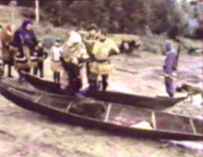
Dugout canoes still used by the
Hanti (Khanty,Ostyaks) of the Ob River
today. These dugouts are limited in size to the largest trees that can
be found in the north, and ridden like open kayaks, and precedents to
kayaks.
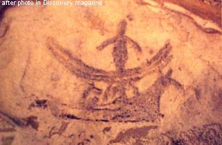
A rock carving from the arctic
coast of
Norway depicting both a one-man dugout, and a skin boat with a
moosehead prow capable of holding several men and dealing with the high
waves of the sea
The above illustration from a rock carving in northern Norway, shows
that knowledge of making dugouts did not die even among peoples who
made skin boats for use on the oceans. . (It was not simply a matter of
cutting a hole in a log, but a skill passed down fhrough the
generations of how to make the hull thin and streamlined, meaning not
any culture could achieve good ones just by observing the final product.)
DUGOUT
BOATS EXPANSION BEYOND EUROPE
There is evidence that boat peoples reached the
Urals about 11,000 years ago, in a unique wooden statue that was found
on a part of the Ural Mountains that was low, situated to the east of
Perm, and to the east side of the mountain range. Figure 12 is a photo
of the head at the top of the very long pole, that was originally stuck
into the ground in or near a bog. The statue-pole fell over into the
bog ans was preserved. Archeological dating has determined it dates to
about 11,000 years ago. Since the "Maglemose" boat peoples culture
dates to about 12,000 years ago, this statue/pole suggests boat peoples
were crossing the Urals into the Ob River water basin at around 11,000
years ago. In addition the pole, they say, was carved with a tool made
from beaver teeth. Mountains peoples could not have made this!
Figure 13
Top
part of the very tall, totem-pole-like Shigir statue/pole from four
sides. Found preserved in a bog at a location where boat people could
cross the Urals, and carved with a tool made of beaver teeth, it was
obviously made by boat peoples. What is significant is that it has been
dated to 11,000 years ago about a millenium after the boat peoples
materialize in the "Maglemose Culture" identified in what is now
Denmark.
Another piece of evidence suggests the boat peoples
may not have stopped at the Ob River, but travelled upriver, portaged
into the Yenisey and eventually into the Lena. Obviously the further
expansion into more eastern rivers would have been later than 11,000
years ago.
The following illustration shows a very large dugout
boat, that is shown on a rock carving at Shishkino on the Lena
River not far from Lake Baikal. If you look at the map of Figure 3. you
will see how explorers in such boats could have reached the area by
river at an early time or later. Note
that it is possible that the people who made the carvings could have
had a new language. We have to be careful to bear in mind that a way of
life can be borrowed/stolen. We cannot automatically assume that these
people came from the "Kunda" culture for example.
If these rock images prove
to be considerably younger than 11,000 years ago, at least it shows that boat peoples COULD
continue eastward, if they had motives to do so. The boat depicted in Figure 14
is clearly a dugout made by hollowing a log. It is too shallow to be
made of skins
Figure 14
Lena River rock art showing large dugouts,
indicative of occasional long journeys.
These carvings (I guess enhanced in
chalk by archeologists) show well made large dugouts. Another image
shows six men. The east Baltic seagoing dugout tradition had places for
three pairs of rowers, and one helmsman with a steering oar. What
is interesting about these images is the headdresses. Since all the men
in the boats have them, it is not a status or ceremonial headdress, but
utilitarian. What I think is shown, is that these men were moose
hunters, and they made headgear out of moose's heads, with ears
attached. The clothing may have looked much like those pyjamas with
ears made for children sometimes.
The following map shows in green the lowland, marshy
regions that boat people could have gone with boats. The map
depicts the situation about 10,000 years ago, The purple dots show the
maximum extend of the Ice Sheets. Everything under it would have been
depressed and flooded when the glaciers withdrew.
Figure 15
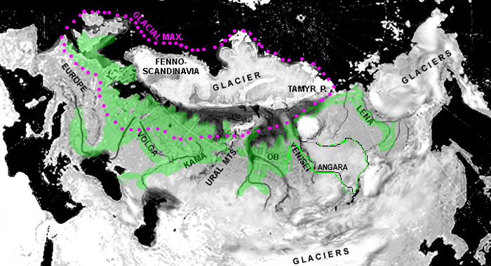
This
map, depicting about 10,000 years ago, with the purple dotted line
representing the maximum extent of the glaciers about 50,000 years ago,
shows in green the regions that boat peoples could have expended,
either through marshy lowlands, or strong rivers. We can only speculate
where they actually managed to go. It is food for thought. The "UIrala"
would be the region within the purple dotted line which was flooded and
depressed by the melting of the glaciers.
DUGOUTS BOATS TO SKIN BOATS AND EXPANSIONS IN THE ARCTIC SEAS
Above we have focussed on the original expansions of the boat
peoples from their origins in the flooded lands where glaciers had
depareted. But there was a more significant expansion of boat people
into harvesting seas, and notably the arctic seas. After those seagoing
boat peoples arising from the "Kunda" culture, sought to harvest
the arctic ocean, they did not
find large enough trees to make large seagoing dugouts, and therefore
invented the skin boat beginning with moose hide on a frame.
See
the next article (#3) for an investigation of the expansion of the boat
peoples from the Baltic to Lake Onega to White Sea, to arctic
Norwegian Seas, northern British Isles, and probably further.
Meanwhile as European civilizations flourished on
the basis of farming-based settlements, the need for traders/shippers
to carry wares between the settlements grew, and the boat peoples found
themselves pre-adapted for the role. The already travelled all year
from campsite to campsite along waterways, returning to the same place
only a year later. Professional traders developed, who made a living
from obtaining wares where they were cheap, and carrying it to where
they were valuable, living off the difference. These professional
traders became an institution on Europe's rivers. This will be the
subject of discussion in a later article.
SOURCES
AND REFERENCES
Since this webpage has been
constantly updated - edited and changed - many sources and references
are
acknowledged where possible in the text or beside the picture. If a
statement is made or picture shown, without a source, that means the
image is either fully original by the author (A.Paabo)or significantly
modified artistically. Significanly mentioned references in the article
above include:
Clark, G, 1967 World Prehistory,
Cambridge A celebrated text that
summarized the accumulated archeological discoveries up to that time.
Since then the ideas have simply been refined.
Jaanits, L. et al, 1982, Eesti
Esiakalugu, Eesti Raamat, Tallinn In
Estonian, the product of Estonian archeological work during the Soviet
period, where the authors were able to access the work of other
archeology within the Soviet Union, not as accessible in the west.
Kozlowski J, and Bandi H-G 1984 The
Paleohistory of Circumpolar
Arctic Colonizationm, Arctic 37 (4): 359-372 Article in English,
where
the investigation of the northeast Europe and the Urals was only one
section. I chose to use it for reference because of this focus, and
because it was a summary.
Rootsi,S., et al. 2006, A counterclockwise northern route of the Y-chromosome haplogroup N from Southeast Asia towards Europe”
European Journal of Human Genetics 15 (2): 204-11 Comment: This is
regarded as the authorative study suggesting the N1c1 haplogroup
migrated up the Ural Mountains and then continued west along the arctic
coast of northeast Europe to the northern Finland area, and then
diffused into the Finno-Ugric speakers from the locations of the
reindeer peoples. .
<MENU
author: A.Paabo, Box 478,
Apsley, Ont., Canada
2017 (c) A. Pääbo.